My first attempts at infusing the feeling of motion into my photographic images originated with my shooting moving objects – cars, trains, people walking or running. (more…)
Read More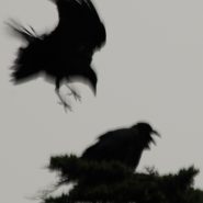
I must confess that my bird images started out, and continue even now, mostly to be a by-product of my landscape photography, which invariably involves a lot of waiting for the light. And waiting is not one of my strong suits. (more…)
Read More
2007
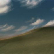
Pacific NW Coast III
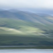
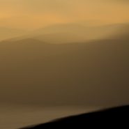
This is my third series captured during my 2010 roadtrip along the northern California and Oregon coasts. Though rarely blessed with optimal light, I was able to take the time for moments of sun to break through. From the cliffs along the Lost Coast in northern California, to the many rivers flowing into the Pacific, to the wonderfully wide and empty Oregon beaches, to tidal Netarts Bay just north of Cape Lookout contained by a five-mile stretch of beach, the Pacific NW coast is rugged and varied.
The south-flowing Pacific current along the NW coast and the weather, both constantly in motion, offer the perfect foil for overlaying my images with a sense of the passage of time.


2007
Pacific NW coast
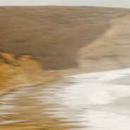
In 2010 I made an extensive roadtrip beginning south of the California-Oregon border traveling north along the rugged and beautiful Pacific NW coast to Astoria, overlooking the Columbia River and the Washington border.
Along this coast are intermittent capes protruding into the Pacific that offer expansive cliff views, interspersed with stretches of very wide beaches, sand dunes, and hundreds of haystacks just offshore, plus the many rivers draining the Coastal mountains, this nearly 500 mile stretch of the northwest coast is simply breathtaking. This series plus the next two comprise my October “capture” of this stretch of the Pacific Northwest coast.


2007
Tomales Bay
Tomales Bay, a 15 mile long by mile wide inlet of the Pacific Ocean, separates Point Reyes Peninsula from the Marin County mainland, 30 miles north of San Francisco. The bay forms the eastern boundary of Point Reyes National Seashore and lies along a submerged portion of the San Andreas Fault.
On its northern end, Tomales Bay opens out onto Bodega Bay, which shelters it from the direct current of the Pacific.
Nestled between the Marin hills to the east and the Point Reyes Peninsula’s rolling hills to the west, this tranquil bay offers lovely views of the edges of these two land masses.


Read More
2007
Drakes Bay
Thirty miles north of San Francisco, southwest facing Drakes Bay is situated on the lee side of the southern coastal current of Point Reyes Peninsula. Long considered Drake’s most likely landing spot on North America’s west cost during his 1579 world circumnavigation,
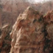
Drakes Bay is backed by dramatic white sandstone cliffs that were created 10-13 million years ago. Erosion has revealed the striations of this story in the cliff faces.
The constant pounding of the Pacific combined with the magnificent 8-mile curved Bay’s tempestuous weather emphasizes the incessant passage of time.


2007
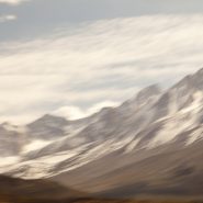
Zabriskie Point lies along the eastern border of California offering sweeping views West across Death Valley’s floor to the Sierra Nevada front-range. The Sierras run 400 miles north-south and 70 miles west-east. Included within this bountiful mountain range is Lake Tahoe, the largest alpine lake in North America, Mount Whitney at 14,505’ the highest point in the contiguous U.S., and Yosemite Valley sculpted by glaciers out of 100 million-year-old granite.
Four million years ago, the Sierra range began to uplift. Subsequent glacial erosion exposed the granite, forming the light-colored mountains we see today. Approaching the Sierra Nevada Range from across Death Valley provides an even more dramatic perspective of the ethereal vertical-rise.


Read More
2007
Containers In, Containers Out
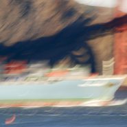
San Francisco’s Golden Gate shipway has a depth of 300’ plus 220’ of bridge clearance allowing the famous Bay entrance access to all forms of commercial shipping. Most prevalent are the container ships plying the Asian-North American markets. Piled high, these ships are spectacular behemoths in size, mass and color, and their graceful, quiet passage provides a visual foil that equals the narrows’ tides and weather and the magnificent Bridge above.


Read More
2007
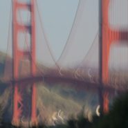
The Bridge
In 1916, a bridge connecting San Francisco to Marin was first seriously considered. Seventeen years later after extensive design and engineering editions, political maneuvering and WWI interruptions, construction finally began. In 1937 the majestic Golden Gate Bridge was completed.
Truly a masterpiece in every sense, the Golden Gate Bridge became the grandest of functional art. Painted orange vermillion to compliment its natural surroundings while still appearing as visible to ships as possible, its aesthetic design is equal to its superior engineering. Who isn’t enamored with its iconic grace?


Read More

2007
San Francisco Coastline
Stretching south from the Golden Gate Bridge, the houses high along Presidio Cliffs gradually descend to Baker Beach and Pt. Lobos beyond, creating spectacular views along this idyllic portion of the San Francisco coastline. The panorama includes the Bridge, Marin Headlands, the ship traffic, the ocean, and on very clear days the Farallon Islands, 27 miles west.
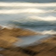
Churning that coastline is the continuous suction of the sea followed by its mad rushes at the mile-wide gate. And the weather is almost always either pushing or pulling, with or against tides. My challenge is to portray that force.


2007
Marin Headlands
Looking north across the golden gate, the Marin Headlands provide a unique perspective; the contrast of the ocean against the colors and textures on the headland’s face. The headland receives the sunlight directly, and reflectively from the water. The channel provides unobstructed first and last light, while the ever-changing weather plays its part.


2007
Dancing With Pelicans
I began photographing the Golden Gate in earnest in 2007, as a daily diversion whenever visiting San Francisco to see my 93 year old, failing mother. From the San Francisco side of the bridge, the Marin Headlands, the Presidio Cliffs and Baker Beach, the mile wide strait, the ocean beyond, the Bridge, and the ships all proved to be ready subjects.
Surrounded by this incredibly diverse and active landscape, pelicans are a reassuring constant, with their grinning profiles as they migrate north in the winter to breed. Brown Pelicans, even with their six-foot wingspans, are the smallest of the eight pelican species and the only ones that dive for fish. Surfacing with their enormous bills full, the water drains leaving the fish to be swallowed. Working the coastline at varying heights in squadron-like formation, upon spotting a school of fish, they skim the water in single file pursuit of their next meal.
Gliding high above the Bay, pelicans are a visual counterpoint to man’s incessant activity at the Golden Gate. Although prehistoric in nature, their peaceful flight is more efficient than man with all his trappings.


1999
Western Space + Time
Having awakened my appetite for large-scale landscape, I explored other western vistas in Wyoming, Utah, California and northern Arizona, in addition to return visits to the high country of Montana. Experimenting with the panoramic format, I found it easier to capture the breadth of the land while more closely matching its flow.
During the creation of this series, I first realized that my obsession with condensing time via motion within a single frame was intimately linked to a lifetime of restlessness.


