2012
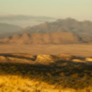
Just south of Santa Fe at the southern terminus of the Rocky Mountains, the Galisteo Basin begins a 2,500′ elevation descent south over 40 miles to the Sandias adjacent to Albuquerque; And to the west it stretches beyond the Rio Grande Rift to the southern end of the foothills of the Jemez Mountains.
Surrounded by these three mountain ranges, the Galisteo Basin’s classic northern New Mexico high desert landscape offers dramatic views in all directions. Having introduced three Galisteo Basin image series captured in 2011, this posting comprises a series of the Galisteo Basin captured from a morning helicopter flight in 2012.
To view more images of the Galisteo Basin, see Galisteo Basin I, Galisteo Basin II and Galisteo Basin III.


2012
Jutting south 150 miles from the southern coast of Alaska, the Kenai Peninsula – derived from Kenayskaya, the Russian name for Cook Inlet — is separated from the mainland on the west by Cook Inlet, and on the east by Prince William Sound. Athabaskan and Alutiiq Native groups have lived on the peninsula for thousands of years.
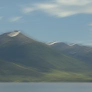
The glacier-covered 7,000′ high Kenai Mountains run down the southeast spine of the peninsula along the coast of the Gulf of Alaska. Kenai Peninsula’s two principal towns are Seward, located on the east coast on the Gulf of Alaska, while Homer, situated on Kachemak Bay, lies along Cook Inlet on the peninsula’s west side.
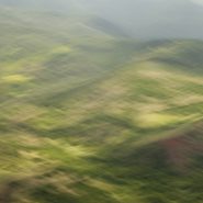
As the glaciers recede on the Kenai Mountains, various stages of gradual re-growth of these denuded mountains provide classic views of very gradual stages of faint green.
After two days of completely socked-in weather in and around Seward, we drove back north, then west across the peninsula, where the weather broke for about a half day, as we headed south allowing visibility along Cook Inlet, Kachemak Bay, and the town of Homer.
With the weather forecasts now calling for continuous clouds for at least another week, we departed Homer and headed back to Anchorage and boarded a return flight to New Mexico a week early.


2012
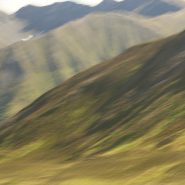
The Chugatch Mountain Range is the most northern of the mountain ranges comprising the western edge of North America. Approximately 250 miles long by 60 miles wide, it extends from the Turnagain Arm at the north end of Cook Inlet, where it bends southeast just south of Anchorage.
Mount Marcus Baker’s 12,884′ elevation is the highest point in the Chugatch Range, which includes 9 mountains above 10,000’ elevation. Situated along the Gulf of Alaska, the very moist air generates more than 600 inches of snow annually — more than anywhere else in the world.
Driving northeast on Alaska A1 (Glenn Hiway) from Wasilla provides stunning views of the northern side of the Chugatch Range, including the Matnuska Glacier.


2012
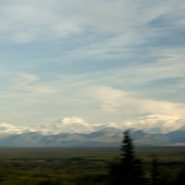
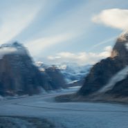
Now that we had flown over the Peter’s Hills to the beginning of Denali’s vertical ascent, in and around this incredibly steep range, landed on and taken off from a glacier, circled the northern side of Denali, and returned the 60 miles back to Talkeetna, the challenge was to capture the entire Denali Mountain from afar. And luck was with us, as it was clear as a bell!
The Alaska Range is the highest in the world outside of Asia and the Andes. It forms a generally east-west arc with its northernmost portion in the center. Acting as a high barrier to the flow of moist air from the Gulf of Alaska northwards, The Alaska Range has some of the harshest weather in the world.


2012
Flying in and landing on a glacier is exciting. Equipped both with wheel landing gear and with skis that can be lowered below the wheels from the cockpit, the pilot’s greatest concern is maintaining depth perception against the ice’s glare.
Ruth Glacier, Denali’s largest, appears to be an interstate, with numerous smaller glaciers feeding into it much like interchanges. Very deceptive from the air, the glacier’s center line is actually a crevice, which on larger glaciers is very wide and often extremely deep, posing much difficulty for climbers to span.
Meanwhile, Ruth Glacier is continuously sliding down the mountain at a rate of about 3 meters per year.


2013
Stretching across Kauai’s northern end, the Na Pali coast’s steep, dramatic terrain is rimmed with narrow beaches and booming surf. It’s vivid colors range from the lush tropical greens to the island’s red, oxidized basaltic foundation and a myriad of colors in between. The crystal clear sunlight intermittently filtered by the voluminous clouds adds a vast and brilliant pacific blue border for this magnificent coast.
I have yet to have a bad day – light wise or cloud-wise – on Kauai! Having lived for the last ten years in the southwest’s high desert country, it was truly a luxury…


For me, landscape reflects the ultimate passage of time. Although Earth is thought to be 4.5 billion years old, almost no portion of it is visible in the landscape today. (more…)
Read More
At last, four years ago, I transferred completely over to Digital Capture. For 6 years prior to that I lived in both camps. (more…)
Read More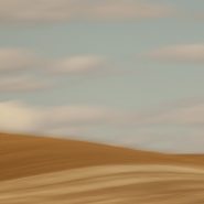
2011
Known for its picturesque, steep, undulating hills, ‘The Palouse’ encompasses the Palouse River watershed rising west out of north-central Idaho’s Blue Mountains to southeastern Washington State, where it turns south emptying into the Snake River.
The unique Palouse region was formed 30 million years ago as the Pacific Plate was pushed beneath the North American Plate, creating a chain of volcanoes that forced molten rock to erupt from cracks in western Oregon’s and Washington’s crust to form the Columbia Plateau basalts. Twenty million years later, the modern Cascade Range lifted up. Two million years ago, glaciers scoured the Pacific NW, generating volcanic silt (“loess”). Prevailing SW winds covered the Palouse’s lava floor with dunes as high as 200’ of wind-blown volcanic silt, resulting in the most fertile land in the northwest.
Lush grasslands provided prime winter grazing for the Nez Perce Indians’ painted ponies, the Appaloosas, until dry land farmers overran this land in the 1880’s. Contour-farming this fertile land for wheat and lentel beans, as high up the slopes as machinery allowed, the varying “painted” shapes have since traced these contours with the seasons’ beautiful patchwork.
Even more visually intriguing than from ground level, this landscape viewed from an isolated 1,000’ high quartzite ‘hill’, Steptoe Butte, offers spectacular aerial views of the Palouse hills.


Read More
2007
Containers In, Containers Out
San Francisco’s Golden Gate shipway has a depth of 300’ plus 220’ of bridge clearance allowing the famous Bay entrance access to all forms of commercial shipping. Most prevalent are the container ships plying the Asian-North American markets. Piled high, these ships are spectacular behemoths in size, mass and color, and their graceful, quiet passage provides a visual foil that equals the narrows’ tides and weather and the magnificent Bridge above.


Read More