2013
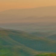
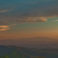
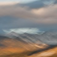
Seen from 8,000′ on the western side of Santa Fe Mountain are wonderful, if partially-obstructed, sunset views — 30 miles across the Rio Grande Valley to the Jemez Mountain range, which roughly parallels the Sangre Christo Mountain range.
Together, these two parallel mountain ranges comprise the southernmost arm of the Rocky Mountains. Elevations gradually descend into lesser mountain groups below Santa Fe.


Read More
2013
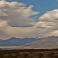
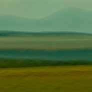
Returning to New Mexico and the splendid variation of topography along its eastern edge, offering spectacular views of its high desert scenery.
North of Santa Fe, 70 miles along the east side of the Rio Grande, lies the western base of the Sangre de Cristo mountains. With a year-round population of nearly 6,000, Taos’ population expands considerably during the winter, as the excellent skiing in Taos is often compared to Jackson Hole.
Taos sits on the eastern edge of the Taos plateau at an elevation of 7,000′, while the mountains further west above Taos soar to 11,000–12,000′.


2003
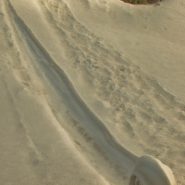
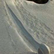
Early one winter morning 15 years ago, driving up Santa Fe Mountain amongst the extensive aspen stands, I rounded a curve to glimpse out of the corner of my eye something I couldn’t believe: slamming on the brakes, I sat looking at a ‟snow spiral” that had formed on a steep slope; after a much closer look, it was obvious to me that it had formed all on it’s own, without any external force other than snow and wind on a steep slope…
Once convinced it had formed naturally, and having never before seen seen anything like it, I spent the next thirty minutes or so capturing it.
Nor have I have seen anything like it since…
Merry Christmas, and Happy New Year!


2018
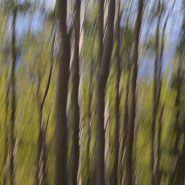
Now winter — the Aspen leaves all gone — the rapidly fading sunlight settles so, so briefly on the fading Aspen forest of trunks before disappearing too, into the night…


2018
With 99% of the leaves above 8,000′ elevation having fallen, only the tall, straight, thin trunks of Santa Fe Mountain’s vast aspen groves remain standing — an array of soft taupe-to-white-to-tan vertical paint strokes — occasionally punctuated by an aberrant leaf’s muted yellow accent and backed by soft, scattered evergreens.
The subtlety and depth of these enormous, deep stands of such wondrously soft colors, all in perfect order, defies imagination…
")
 II")
 III")
 IV")
 V")
 VI")
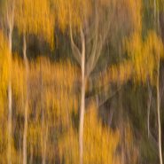
2018
Still up on top of Santa Fe Mountain, as Autumn temperatures continue dropping, the aspen leaves achieve their spectacular golden yellow peak just as their tall, slender stems take on a contrasting palette of various shades of a grey-to-taupe.
By adding further contrast with my camera strokes, I’m able to blend these elements and colors, backed by the intermingling evergreens.
")
 II")
 III")
 IV")
 V")
 VI")
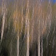
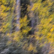
2018
As the temperature drops above 8,000′ elevation in early autumn, the aspen’s leaves commence turning — initially from green to bright yellow, through various hues of gold and lastly to surprising shades of orange — while the tall, slender and graceful trunks subtly shift from white to taupe.
Just north of Santa Fe, along the western edge of the Sangre de Cristo Mountain Range among Santa Fe Mountain’s extensive aspen stands, most of the groves begin their turn dramatically at the same time. Others change at a different pace, depending on their particular exposure to sun and wind.
These out-of-sync aspen turns are invariably more muted, with the leaves’ change often blending closely with their trunks — creating quiet, blended tapestries that are contrasted against nearby evergreens.
Overlaying these quiet forest tapestries with minimal camera strokes enables me to achieve the antidote to my lifetime preoccupation to control time. It’s no accident that my landscapes convey the serenity I have always sought in my own life…


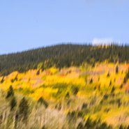
2018
Every mid-September to mid-October, as the temperature begins dropping, aspen leaves — beginning above 8,000′ elevation on many western mountains — turn from green to bright yellow, then gold, and finally to various shades of orange, while the tall, slender, graceful trunks subtly shift from white to taupe-to-cream.
Santa Fe Mountain, immediately north of Santa Fe, and on the western side of the Sangre de Cristo Mountain Range, is one of those western mountains blessed with large aspen groves.
The ten mile drive from Santa Fe’s central square up Santa Fe’s ski mountain provides nearly continuous visual access to its many aspen groves. In fact, during early fall, it has become an annual ‘right of passage’ for residents, as well as many visitors, to go up Santa Fe mountain to see and photograph the Aspen Turning.
Having been traveling a lot during fall months, I’ve missed this early fall pilgrimage for the past 5-6 years. But this year I am remaining here in Santa Fe, and I have promised myself to spend time up on Santa Fe Mountain every possible day I can.
And, in turn, to devote the next 7 blogs — through the end of the year — to my various interpretations of ASPEN TURNING…


2013
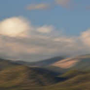
From about 10,000 feet elevation on Santa Fe Mountain — Santa Fe’s ski mountain — where the ski lifts rise to 13,200′ – views toward the South and Southwest offer classic New Mexico mountainous landscape under New Mexico’s equally spectacular, colorful skies.
I moved from the eastern shore of Maryland 15 years ago to place myself at the eastern edge of the amazing landscape throughout America’s west – as have so many artists of all kinds who have moved here over the last 100 years.
Never have I tired of the amazing visual access to nature’s unending western beauty.
I captured this group of pictures one evening while showing the view to out-of-town friends. I spent about an hour capturing some 20 images, from which these five best reflect my 40 year+ compulsion to overlay my images with some sense of the ever-fleeting passage of time.


2011
Within the Sangre de Christo mountain range, 25 miles north of Santa Fe, are situated the Truchas Peaks (Spanish for “trout”). This range of four summits include the 13,102′ South Truchas Peak – the second highest peak in New Mexico – and the 13,024′ North Truchas Peak.
The birth of the Sangre de Cristos Mountains — the southernmost subrange of the Rockies — occurred 80 million years ago as the Farrallon Plate slid under the North American Plate at such a shallow angle that it formed a wider belt of north-south mountains, resulting in a broader region of lower mountains farther inland.
During the succeeding 60 million years, erosion stripped away the high rocks to reveal the ancestral rocks beneath that have since been eroded by water and glaciers, sculpting the mountains into more dramatic peaks and valleys.
Shooting east during late afternoon light, while simultaneously stroking my camera south, enabled me to intensify the texture of these north-south trending subranges of the Truchas Peaks
The fourth and final set of Truchas Peaks images, each resulting once again from single exposure camera pans, as I blend the varying textures with the constantly changing light.


2011
Within the Sangre de Christo mountain range, 25 miles north of Santa Fe, are situated the Truchas Peaks (Spanish for “trout”). This range of four summits include the 13,102′ South Truchas Peak – the second highest peak in New Mexico – and the 13,024′ North Truchas Peak.
The birth of the Sangre de Cristos Mountains — the southernmost subrange of the Rockies — occurred 80 million years ago as the Farrallon Plate slid under the North American Plate at such a shallow angle that it formed a wider belt of north-south mountains, resulting in a broader region of lower mountains farther inland.
During the succeeding 60 million years, erosion stripped away the high rocks to reveal the ancestral rocks beneath that have since been eroded by water and glaciers, sculpting the mountains into more dramatic peaks and valleys.
Shooting east during late afternoon light, while simultaneously stroking my camera south, enabled me to intensify the texture of these north-south trending subranges of the Truchas Peaks.
My third continuation of six images — each being a single exposure — by panning these magnificent Peaks at different speeds and at varying angles, and, of course, with varying light.


2011
Within the Sangre de Christo mountain range, 25 miles north of Santa Fe, are situated the Truchas Peaks (Spanish for “trout”). This range of four summits include the 13,102′ South Truchas Peak – the second highest peak in New Mexico – and the 13,024′ North Truchas Peak.
The birth of the Sangre de Cristos Mountains — the southernmost subrange of the Rockies — occurred 80 million years ago as the Farrallon Plate slid under the North American Plate at such a shallow angle that it formed a wider belt of north-south mountains, resulting in a broader region of lower mountains farther inland.
During the succeeding 60 million years, erosion stripped away the high rocks to reveal the ancestral rocks beneath that have since been eroded by water and glaciers, sculpting the mountains into more dramatic peaks and valleys.
Shooting east during late afternoon light, while simultaneously stroking my camera south, enabled me to intensify the texture of these north-south trending subranges of the Truchas Peaks.


2011
Twenty five miles northeast of Santa Fe, within the Sangre de Cristo Mountain range are a range of four identifiable summits. Truchas Peaks (Spanish for “trout”) encompass a north-south trending subrange of identifiable summits, which includes the 13,102′ South Truchas Peak — the second highest independent peak in New Mexico, as well as the 13,024′ North Truchas Peak.
The birth of the Sangre de Cristo Mountains, the southernmost subrange of the Rockies, began 80 million years ago when the Farallon Plate slid under the North American Plate at such a shallow subduction, it created a broad belt of mountaIns running south down North America. The low angle moved the focus of crustal melting and mountain building much farther inland than the normal 2-300 miles. Over the past 60 million years, erosion has stripped away the high rocks, revealing the ancestral rocks beneath, which have since been eroded by water and glaciers, sculpting the Rockies into dramatic peaks and valleys.
Being fortunate to capture Truchas Peaks immediately following a first snow in late light, I found this to be one of the more magnificent mountain groups within the Sangre de Cristo Mountains, blending vistas of magnificent peaks together with perfect sky and clouds…


2011
1,500’ lower, the East Face of the Sangre de Cristo Mountains continues a long descent down to the plains. Looking back 20 miles to the west across farms and ranches, the harsh light of the setting sun is blocked first by the Jemez Mountains, then by the western slopes of the Sangres, resulting in the east side appearing much softer.
The climate is also much milder in the eastern lee of the Sangres, due to considerably more precipitation.


2003
Early one winter morning 14 years ago, shortly after moving to Santa Fe, amidst its wonderful high desert landscape, I was driving up Santa Fe Mountain’s west face to continue my photographic study of its extensive Aspen stands. Upon rounding a sharp curve in the road — I happened upon an astounding and sublime surprise: a “snow spiral” which apparently had formed rolling down the steep slope. Not certain what I glimpsed, I stopped to take a closer look. And having never before seen anything like it, I just had to capture it!
Nor have I ever seen anything like it since…
Enjoy! Merry Christmas


2015
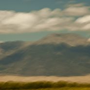
From 20 miles north of Santa Fe, my third and final series of the west face of the Sangre de Cristo mountain range. President Clinton was fond of saying, “its the economy stupid!”
Well, in photography, it’s all about the light…
On this day, the sun was “out full bore,” and because my captures were slightly earlier in the day, the sun still cleared the Jemiz Mountain range behind me; sunlight shined directly on Santa Fe Baldy, the highest peak in this section of the range. Blending the highlighted west face amongst its shadowed surroundings offered a very different series of compositions.


2015
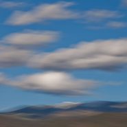
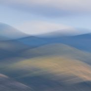
Another series of captures from “my” 8,500′ ridge vantage point, 20 miles north of Santa Fe, offers dramatic “takes” of the Sangre’s west face — including its foothills — leading up to its 12,000′ peaks perched under a late afternoon sky.
As direct sunlight still bathes the nearby foothills, the receding Sangre peaks read as a distant blue line of demarcation that separate the Blood of Christ ridge from the Western cloud-laden sky. These three receding horizontal elements of color and texture afford an array of blending possibilities…


2015
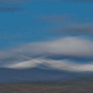
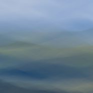
Returning to one of my favorite New Mexico palettes — just twenty miles north of my home in Santa Fe — an accessible 8,500 foot ridge offers unobstructed views across the 2-3 mile wide valley directly into the entire west face of the Blood of Christ mountain range, from its foothills all the way up and beyond its 12,000′ peaks, which are so often crowned with a continuously-modulating cloud cap as the evening light descends.
An always-varying palette of color, shadow, texture and form…


2013
15 miles north of Blanca Peak, a Colorado sand dune field emerged as a result of the last major volcanic activity in the San Juan Mountains some 30 million years ago. As the Rio Grande carried volcanic ash eastward, prevailing southwesterly winds – offset by the Sangre de Cristo Mountains’ snowmelt – maintained the unique balance of these trapped dunes: shifting back and forth according to the strength and direction of the prevailing wind relative to the degree of the snowmelt’s runoff.
Reaching heights of 750′, these are the highest and tallest sand dunes in North America.
Native Americans have long observed this unique dune field’s wandering, shifting nature: the Jicarilla Apaches: “it goes up and down,” and the Utes: “the land that moves back and forth.”


2014
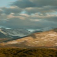
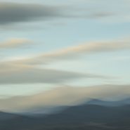
The tenth and final successive exploration (at least for now) of the west face of Santa Fe Baldy’s portion of the Sangre de Cristo range, immediately north of Santa Fe.
Eight months since my last exploration, the setting sun, through clouds scattered over the Jemez range 20 miles west, slowly diffuses Santa Fe Baldy’s own atmospherics.


