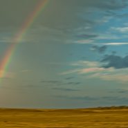
2012
Photographed during a Monsoon just south of Santa Fe in the Galisteo Basin.
Mid-New Mexico monsoons typically occur during July and August, and are generalized by sporadic, intense thunder storms, lightning, a whole lot of rain, and beautiful rainbows.
It’s not uncommon to hear the refrain that Santa Fe only gets 7-8 inches of rain a year, usually in about 45 minutes!


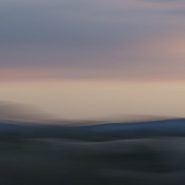
2014
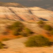
Continuing my visual exploration of the Ortiz Mountains, I have augmented each of these images with a stretched sense of the passage of time — in order to emphasize and meld the 30 million years consumed in their creation. Panning my camera of this small mountain range at shutter speeds of less than 1/15 second, takes me a step toward my own pursuit of Virtual Reality!


2014
A while back, I had the opportunity to ‘house-sit’ for friends who live on a ridge overlooking the Ortiz Mountains in the southern quadrant of Galisteo Basin, twenty miles south of my home in Santa Fe. Three weeks of this particular view gave me the opportunity to pursue different visual themes of the Ortiz: more or less straightforward photographic capture, plus overlaying the scene with varying motion strokes to stretch, and cross-cut the scene; and then to incorporate dramatic first and last New Mexico light to once again re-integrate my strokes.


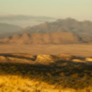
2012
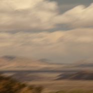
Just south of Santa Fe at the southern terminus of the Rocky Mountains, the Galisteo Basin begins a 2,500′ elevation descent south over 40 miles to the Sandias adjacent to Albuquerque; And to the west it stretches beyond the Rio Grande Rift to the southern end of the foothills of the Jemez Mountains.
Surrounded by these three mountain ranges, the Galisteo Basin’s classic northern New Mexico high desert landscape offers dramatic views in all directions. Having introduced three Galisteo Basin image series captured in 2011, this posting comprises a series of the Galisteo Basin captured from a morning helicopter flight in 2012.
To view more images of the Galisteo Basin, see Galisteo Basin I, Galisteo Basin II and Galisteo Basin III.


At last, four years ago, I transferred completely over to Digital Capture. For 6 years prior to that I lived in both camps. (more…)
Read More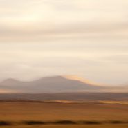
2011
Concentrating once again on the Galisteo Basin, situated between Santa Fe and Albuquerque, I captured the mountain ranges in its south and west quadrants, plus to the north the very southern end of the last of the Sangre de Cristo foothills – such beautiful high desert light emphasizing their relative elevations.
To view more images of Galisteo Basin, see Galisteo Basin I and Galisteo Basin II


2011
So taken by this basin’s spectacular views at Santa Fe’s southern doorstep, I find myself returning again and again.
An upwelling of the Earth’s mantle thirty million years ago caused a pair of parallel fault zones, 40 miles apart, to cut north-south through New Mexico from the San Juan Mountains in south central Colorado to the southwestern tip of Texas; 8-10 million years later, this slice of the Earth’s crust sank as much as 5 miles, creating the Rio Grande Rift, which in turn extended a network of fault patterns that pulled apart the Earth’s crust to the breaking point. From the Rio Grande Rift west to the Sierras, these faults were the genesis of the southwest’s predominate Basin & Range topography: fallen crustal blocks created basins; uplifted blocks became mountain ranges.
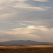
Low-angled high-desert light with some cloud cover makes it possible to emphasize the differing characters of these surrounding mountains
To view more images of Galisteo Basin, see Galisteo Basin I and Galisteo Basin III


2011
The Galisteo Basin is classic northern New Mexico high desert landscape. Surrounded by very visible mountain ranges this basin is situated on the east side of the Rio Grande between Santa Fe and Albuquerque. Tilted, and interspersed with wide-open plateaus, the basin offers dramatic views in all directions.
This particular series is the result of one afternoon’s roadtrip south from Galisteo to Stanley, along the east side of the Ortiz, Captain Davis and Lone Mountains, and further south, east of the Sandia Mountains.
Like so much of the American west, what is visible today was formed over the last 30 million years, amounting to less than 1% of the Earth’s 4.6 billion year age
To view more images of Galisteo Basin, see Galisteo Basin II and Galisteo Basin III


