2016
The next day’s weather enabled me to gradually alter the landscape’s texture against cloud movement…


2013
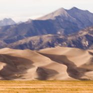
15 miles north of Blanca Peak, a Colorado sand dune field emerged as a result of the last major volcanic activity in the San Juan Mountains some 30 million years ago. As the Rio Grande carried volcanic ash eastward, prevailing southwesterly winds – offset by the Sangre de Cristo Mountains’ snowmelt – maintained the unique balance of these trapped dunes: shifting back and forth according to the strength and direction of the prevailing wind relative to the degree of the snowmelt’s runoff.
Reaching heights of 750′, these are the highest and tallest sand dunes in North America.
Native Americans have long observed this unique dune field’s wandering, shifting nature: the Jicarilla Apaches: “it goes up and down,” and the Utes: “the land that moves back and forth.”


2013
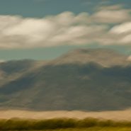
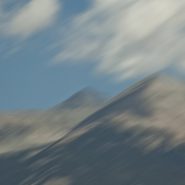
Twenty miles northeast of Alamosa, at the very southern end of the more extensive Sangre de Cristo range, Blanca Peak, at 14,351′, is the highest summit of the Sierra Blanca Massif, the Sangre de Cristo Mountains, as well as the highest point within the Rio Grande’s entire drainage basin. In addition to being the fourth highest peak in Colorado, Blanca Peak is higher than any point east in the U.S.
Known to the Navajo nation as the Sacred Mountain of the East, Blanca Peak is considered to be the eastern boundary of the Dinetah, the traditional Navajo homeland.


2013
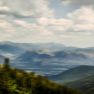
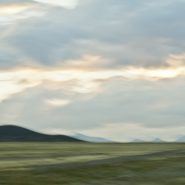
San Luis Valley — 8,000 sq. miles, averaging 7,600′ elevation — is the largest high desert valley in North America. Situated in south central Colorado, with a small portion extending south into central New Mexico, this gradually-sloping, 122 mile long north-to-south flat basin, 74 miles wide, separates Colorado’s two largest mountain ranges – the San Juans to the west, and the Sangre de Cristos to the east.
As part of the Rio Grande Rift, San Luis Valley extends east from the Continental Divide. The Rio Grande River rises out of the eastern San Juan Mountains and flows south into New Mexico; Colorado rivers west of the Continental Divide are drained by the Colorado River. Receiving little precipitation, the San Luis Valley is comprised of desert lands; with no clear southern boundary, it is generally considered to include the San Luis Hills of southern Colorado and the Taos Plateau of northern New Mexico.
Along the eastern edge of San Luis Valley are two significant features:
Blanca Peak, at 14,351′, is the fourth highest mountain in Colorado, and the highest peak in the Sangre de Cristo Mountains. Situated at the southern end of the more extensive Sangre de Cristo Range, it is the highest peak in both ranges, and is located 20 miles east-northeast of the town of Alamosa. Blanca Peak is also the highest point of the entire drainage basin of the Rio Grande, and is higher than any point in the U.S. east of its longitude.
Fifteen miles northwest of Blanca Peak, the Great Sand Dunes National Park and Preserve is situated in the lee of the Sangre de Cristos. These sand dunes, reaching as high as 750′, are the highest in North America.


2013
At 12,095′ elevation, this narrow strip of the Continental Divide is the high and extensive Sawatch Range of the Rocky Mountains of central Colorado. Situated midway between Aspen and Twin Lakes, it includes eight of the twenty highest Rocky Mountain peaks. Independence Pass is the highest paved crossing of the Continental Divide in the US.
Overlooking the alpine tundra environment above the treeline, Independence Pass offers incredible views east of Mt. Elbert, Colorado’s highest peak, and the second highest mountain in the contiguous United States.


2013
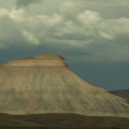
Mount Garfield at 6,780′ elevation is the high point of the Book Cliffs range — a series of desert mountains and cliffs stretching 200 miles from western Colorado into eastern Utah, north of Grand Junction. Appearing primarily along the southern and western edge of the Tavaputs Plateau, these cliffs are largely composed of sedimentary materials that cap many of the south-facing buttes, appearing similar to a shelf of books.
Within the Colorado Plateau geologic province, these cliffs of Cretaceous sandstone begin where the Colorado River descends south through De Beque Canyon into the Grand Valley before running west to Price Canyon near Helper, UT.


2007
As the sun drops behind the San Juan Mountains, 75 miles across the San Luis Valley, the last direct light on North America‘s tallest and highest dunes causes the volcanic sand to glow.
This Colorado dune field evolved out of the last major volcanic activity in the San Juan Mountains, 30 million years ago. The Rio Grande carried volcanic ash eastward, while prevailing southwesterly winds plus the snowmelt from the Sangre de Cristo Mountains have maintained its unique balance.
My own visual interpretation of the events that have created this particular evolution in the passage of time is not unlike The Jicarilla Apaches’ “it goes up and down” and the Utes’ “the land that moves back and forth.”


2007
Driving West to the Grand Canyon from Santa Fe, five miles east of the Continental Divide, at 7,200’ elevation, the sun’s low angle dramatically rakes the south face of the Colorado Plateau’s sandstone cliffs.


