2017
Dubrovnik’s long history of survival
For more than 3,000 years, the Adriatic has been the most practical trade route between Europe and the East. And for centuries, Croatia has been a buffer zone between east and west and between north and south.
Recorded history in Croatia starts with the Illyrians, a group of tribes that shared building and funeral techniques. By the 7th century BC, the Illyrians were trading with the ancient Greeks, and within two centuries the Greeks had established colonies in the area, notably Pharos (now Stari Grad) on the island of Hvar. By 229 BC, the Greeks were calling on Rome to help them in their quest to dominate the region.
In 1205 Dubrovnik came under Venetian control in the Adriatic, remaining under their sovereignty until 1358, when it became part of the Hungarian-Croatian kingdom. By then Dubrovnik was also becoming a trading state of increasing importance. Capitalizing on its fortunate position, Dubrovnik developed a strong seafaring tradition, eventually establishing trade routes all the way to Spain, Portugal and England.
In the early 14th century, after a huge fire destroyed most of Dubrovnik, a new urban plan was developed. At the beginning of the 15th century the remaining wooden houses in Dubrovnik were demolished and rebuilt in stone, in order to prevent fires from spreading.
By that time, Dubrovnik flourished as a haven of liberalism, allowing Dominicans and Franciscans within the city walls and offering asylum to refugees, including Jews, when many other cities turned them away at the gate. Dubrovnik abolished slavery in 1416, more than 400 years ahead of Britain (1833) and America (1863). Many slaves subsequently had their freedom bought for them by Dubrovnik nobles. The republics’s wealth was put to good use in a major building program.
Tragically, an earthquake destroyed most of the city in 1520, and the plague returned in force in 1528, killing more than 20,000 people. By the end of the 1520s, the Turks had pretty much defeated Hungary, and Dubrovnik was quick to change its allegiance from the Hungarian king to the Turkish sultan.
In 1588 Dubrovnik joined the Spanish in their ‘Invincible Armada’, losing a dozen of its finest ships and interrupting trade with Britain for nearly two centuries. New trade routes across the Atlantic made Britain, Spain and Portugal into wealthy nations; Mediterranean shipping was never to regain its former importance.
Disaster struck again in April 1667, when a massive earthquake destroyed Dubrovnik, killing more than 5,000 people, including the entire Minor Council and more than half of the Great Council. Dubrovnik’s massive rebuilding program continued through the early 18th century. By the end of the 18th century, Dubrovnik had regained a considerable amount of its wealth and standing.
Unfortunately, however, on May 26,1806, Napoleon broke a month-long siege by Russian and Montenegrin forces, and the republic allowed a French garrison to enter Dubrovnik. Once installed, the French didn’t leave. In 1809, Dubrovnik was absorbed into the newly created French ‘Illyrian Provinces’ stretching up the Adriatic Coast to Trieste. When Napoleon was finally defeated, Austria sent troops south and took control of Dubrovnik in 1814. A century later Dubrovnik became part of Yugoslavia.


Read More
2017
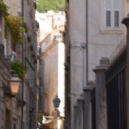
The biggest draw in Southern Croatia is the extraordinary walled city of Dubrovnik, with a remarkable history stretching back well over 1,000 years. Walls up to 80′ high, complete with fortresses and towers, with an ancient footpath along the 2 mile-long wall encircling the stone-built, red-roofed city, offer incredible views of the clearest blue-green waters of the Adriatic. The streets are paved with time-polished pale marble.
The town’s harmony owes much to the 17th century rebuilding program following the Great Earthquake in 1667.


2017
Croatia includes more than 1,200 islands, rocks and reefs off its east coast, facing Italy 100 miles across the Adriatic sea. Only 48 of the islands are inhabited.
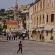
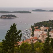
Split, Croatia’s second largest city, is situated on the Dalmatian Coast; just off its shoreline is Croatia’s fourth largest island, Hvar, situated at the center of the Adriatic sailing routes.
Hvar has always been an important base for commanding trade up and down the Adriatic, west across to Italy, and throughout the wider Mediterranean to the south. Inhabited since prehistoric times, initially by a Neolithic people whose distinctive pottery gave name to the Hvar culture, and later by the Illyrians. The ancient Greeks founded the colony of Pharos in 384 BC on Hvar’s Stari Grad, making it one of the oldest towns in Europe. They were also responsible for setting out the agricultural field divisions of the Stari Grad Plain, now a UNESCO World Heritage Site.
In medieval times Hvar city rose to importance within the Venetian Empire as a major naval base. Prosperity brought culture and the arts, with one of the first public theaters in Europe, nobles’ palaces, and many fine communal buildings.
The 16th century was an unsettled time, with the Hvar Rebellion, coastal raids by pirates and the Ottoman army invading from the mainland. After a brief time under Napoleonic rule, the island became part of the Austrian Empire, a more peaceful and prosperous period.
About 1900, construction of accommodations for visitors began to grow. Since then, the island’s growth has developed into an almost continual expansion of hotels, apartments, restaurants, marinas, museums, galleries and cafes. Today, Hvar is a popular destination, consistently listed in the ‘top 10 Islands’ by Conde Nast Traveler magazine.
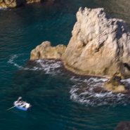
With classic Mediterranean weather and ancient architecture, the islands off Split are beautiful, and so very interesting.


2017
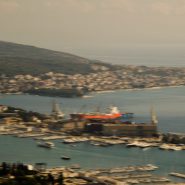
Zagreb is Croatia’s Capital and largest city, with a population of just over 800,000. Split is Croatia’s second largest city, and at 300,000 population the largest city within the Dalmatian region. Situated on the eastern shore of the Adriatic Sea, the city is spread out along a central peninsula.
Home to Diocletian’s Palace, built for the Roman emperor in AD 305, Split was founded as the Greek colony of Aspalathos in the 3rd or 2nd century BC. It became a prominent settlement around 650 AD when it succeeded the ancient capital of the Roman province, Solana.
Split became a Byzantine city, while later gradually drifting into the sphere of the Republic of Venice and the kingdom of Croatia. For much of the High and Middle ages, Split enjoyed autonomy as a free city, caught in the middle of a struggle between Venice and the King of Hungary for control over the Dalmatian cities.
Venice eventually prevailed and during the early modern period Split remained a Venetian city — a heavily fortified outpost surrounded by Ottoman territory. Its hinterland was won from the Ottomans in the Morean War of 1699; in 1797, as Venice fell to Napoleon in the Treaty of Campo Formio, Split went to the Hapsburg Monarchy. In 1805, the Peace of Pressburg added Split to the Napoleonic Kingdom of Italy, becoming part of the Illyrian Provinces in 1809. After being occupied in 1813, it was eventually granted to the Austrian Empire following the Congress of Vienna; the city remained a part of the Austrian Kingdom of Dalmatia until the fall of Austria-Hungary in 1918. Reoccupied by Germany in WWII, Split was part of the puppet State of Croatia. It was liberated again by partisans in 1944 and became part of post-war Socialist Yugoslavia. In 1991, Croatia seceded from Yugoslavia during the Croatian War of Independence.
Centrally situated along the Dalmatian Coast, over the last five years Split has become very much the center of Croatia’s rapidly-growing tourism trade, with its proximity to Italy, miles of Adriatic shore line and countless close and lovely Croatian islands. And its weather is classically Mediterranean!


2017
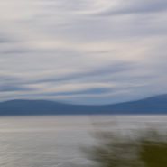
The Adriatic Sea, roughly 100 miles wide, begins at the Mediterranean Sea and runs northwest about 800 miles to where Italy, Slovenia and Croatia come together at its northern terminus, while The Adriatic Sea separates Italy from the eastern Balkan Peninsula for its entire length.
Along the eastern side of the Adriatic Sea, the eastern Balkan Peninsula (North-to-South), includes Croatia, Bosnia & Herzegovina, Montenegro, Albania, and Greece. Beginning at Croatia’s north end, the Dalmatian Coast extends south-southeast.
The Dalmation Coast’s high limestone elevations offer wonderful views of its own coast line, its many just off-shore islands, tropical Mediterranean weather and sea, as well as occasional glimpses of Italy’s distant coast.


2017
The Adriatic Sea, roughly 100 miles wide, begins at the Mediterranean Sea and runs northwest about 800 miles to where Italy, Slovenia and Croatia come together at its northern terminus. The Adriatic Sea separates Italy from the eastern Balkan Peninsula for its entire length.
Along the eastern side of the Adriatic Sea, the eastern Balkan Peninsula (North-to-South), includes Croatia, Bosnia & Herzegovina, Montenegro, Albania, and Greece.
From its northern end, at Slovenia, Croatia’s Dalmatian Coast extends south-southeast, opposite Italy, all the way southeast to just beyond Dubrovnik, at its border with Montenegro.
The Dalmatian Coast’s strong Italian influence stretches back to Italy’s occupation of the Coast by the Romans in 12 AD, which lasted, off and on, for nearly 400 years.


2017
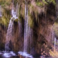
An Alive Mountain. One of the more compelling landscapes I’ve encountered.
I must return to make more images.


2017
A Visual Feast of An Alive Mountain
Water constantly bubbling up out of the ground — everywhere — then rushing down the mountain, forming hundreds of waterfalls throughout the surrounding forest’s beautiful autumn colors. All of this being the result of complex underground karstic limestone dissolution occurring since the end of the last ice age 12,000 to 15,000 years ago.
How then, to capture this unceasing bubbling motion against the otherwise still mountain?


2017
Founded in 1949, Croatia’s Plitvice Lakes National Park, at its border with Bosnia and Herzegovina, is about 40 miles east of the Adriatic coast. One of the oldest and the largest national park in Croatia, Plitvice Lakes was added to the UNESCO World Heritage register in 1979.
The Plitvice Lakes were formed in a depression between Mala Kapela mountain to the west and the Plitesevica mountain to the east, within the Dinaric Alps. Its 16 lakes, visible from the surface are grouped into 12 upper, four lower lakes.
Between a narrow opening in the mountains to the south, and the Korona River exiting to the north, through a steep and narrow draw that accommodates the entire 3,000′ altitude differential within the park.
The underground configuration of the Plitvice Lakes consists of geologic features attributed to the southeast European Karsk of brittle porous limestone, which allows rivers to drain away through the rock to create extensive underground river systems, and caves. Upon reaching hard rock, rivers emerge on the surface. The phenomenon of underground karst rivers, observed at Plitvice Lakes, are the result of century-old processes of sedimentation of chalk, which is abundantly available in the waters of this karst area.
Geologically, the phenomena molding the Plitvice Lakes is quite young. According to radiocarbon datings, the complex processes of dissolution and sedimentation of limestone require specific climatic preconditions, which have only existed since the end of the ice age 12,000 to 15,000 years ago.
Plitvice National Park is spectacular! Constantly flowing waters bubbling up and out of the ground everywhere, then flowing downward steeply, causing hundreds of waterfalls – all against the beautiful mountain sky, striking autumn colors, and awesome light. What a visual feast!


Read More