2011
New Mexico’s Bosque del Apache (Spanish for Woods of the Apache) is located 90 miles south of Albuquerque, along the Rio Grande. Established in 1939, this tiny high desert wetland National Wildlife Refuge was created to protect the endangered Sandhill Cranes heading down the continent ahead of winter in November; and again on their return North in February and March for breeding season.
Eighty years later, Bosque de Apache has been enlarged considerably, and now serves as a migratory resting place for hundreds of thousands of snow geese, 10-15,000 Sandhill Cranes, and a wide assortment of other migratory fowl. Now each November is known for the ‘Return of the of the Sandhills Celebration.’


2013
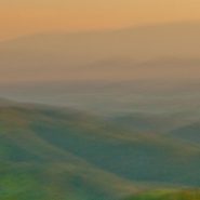
Seen from 8,000′ on the western side of Santa Fe Mountain are wonderful, if partially-obstructed, sunset views — 30 miles across the Rio Grande Valley to the Jemez Mountain range, which roughly parallels the Sangre Christo Mountain range.
Together, these two parallel mountain ranges comprise the southernmost arm of the Rocky Mountains. Elevations gradually descend into lesser mountain groups below Santa Fe.


Read More
2017
The Adriatic Sea, roughly 100 miles wide, begins at the Mediterranean Sea and runs northwest about 800 miles to where Italy, Slovenia and Croatia come together at its northern terminus. The Adriatic Sea separates Italy from the eastern Balkan Peninsula for its entire length.
Along the eastern side of the Adriatic Sea, the eastern Balkan Peninsula (North-to-South), includes Croatia, Bosnia & Herzegovina, Montenegro, Albania, and Greece.
From its northern end, at Slovenia, Croatia’s Dalmatian Coast extends south-southeast, opposite Italy, all the way southeast to just beyond Dubrovnik, at its border with Montenegro.
The Dalmatian Coast’s strong Italian influence stretches back to Italy’s occupation of the Coast by the Romans in 12 AD, which lasted, off and on, for nearly 400 years.


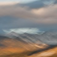
2011
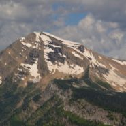
Within the Sangre de Christo mountain range, 25 miles north of Santa Fe, are situated the Truchas Peaks (Spanish for “trout”). This range of four summits include the 13,102′ South Truchas Peak – the second highest peak in New Mexico – and the 13,024′ North Truchas Peak.
The birth of the Sangre de Cristos Mountains — the southernmost subrange of the Rockies — occurred 80 million years ago as the Farrallon Plate slid under the North American Plate at such a shallow angle that it formed a wider belt of north-south mountains, resulting in a broader region of lower mountains farther inland.
During the succeeding 60 million years, erosion stripped away the high rocks to reveal the ancestral rocks beneath that have since been eroded by water and glaciers, sculpting the mountains into more dramatic peaks and valleys.
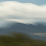
Shooting east during late afternoon light, while simultaneously stroking my camera south, enabled me to intensify the texture of these north-south trending subranges of the Truchas Peaks.
My third continuation of six images — each being a single exposure — by panning these magnificent Peaks at different speeds and at varying angles, and, of course, with varying light.


2011
Within the Sangre de Christo mountain range, 25 miles north of Santa Fe, are situated the Truchas Peaks (Spanish for “trout”). This range of four summits include the 13,102′ South Truchas Peak – the second highest peak in New Mexico – and the 13,024′ North Truchas Peak.
The birth of the Sangre de Cristos Mountains — the southernmost subrange of the Rockies — occurred 80 million years ago as the Farrallon Plate slid under the North American Plate at such a shallow angle that it formed a wider belt of north-south mountains, resulting in a broader region of lower mountains farther inland.
During the succeeding 60 million years, erosion stripped away the high rocks to reveal the ancestral rocks beneath that have since been eroded by water and glaciers, sculpting the mountains into more dramatic peaks and valleys.
Shooting east during late afternoon light, while simultaneously stroking my camera south, enabled me to intensify the texture of these north-south trending subranges of the Truchas Peaks.


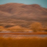
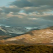
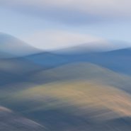
2011
Twenty five miles northeast of Santa Fe, within the Sangre de Cristo Mountain range are a range of four identifiable summits. Truchas Peaks (Spanish for “trout”) encompass a north-south trending subrange of identifiable summits, which includes the 13,102′ South Truchas Peak — the second highest independent peak in New Mexico, as well as the 13,024′ North Truchas Peak.
The birth of the Sangre de Cristo Mountains, the southernmost subrange of the Rockies, began 80 million years ago when the Farallon Plate slid under the North American Plate at such a shallow subduction, it created a broad belt of mountaIns running south down North America. The low angle moved the focus of crustal melting and mountain building much farther inland than the normal 2-300 miles. Over the past 60 million years, erosion has stripped away the high rocks, revealing the ancestral rocks beneath, which have since been eroded by water and glaciers, sculpting the Rockies into dramatic peaks and valleys.
Being fortunate to capture Truchas Peaks immediately following a first snow in late light, I found this to be one of the more magnificent mountain groups within the Sangre de Cristo Mountains, blending vistas of magnificent peaks together with perfect sky and clouds…


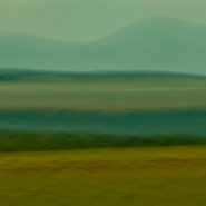
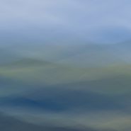
2011
1,500’ lower, the East Face of the Sangre de Cristo Mountains continues a long descent down to the plains. Looking back 20 miles to the west across farms and ranches, the harsh light of the setting sun is blocked first by the Jemez Mountains, then by the western slopes of the Sangres, resulting in the east side appearing much softer.
The climate is also much milder in the eastern lee of the Sangres, due to considerably more precipitation.


2011
One hour north of Santa Fe is Georgia O’Keefe Country: vast vistas, table-topped mesas, tall cliffs, and winding rivers bordered by ancient cottonwoods.
Because this block of the earth’s crust remained relatively stable for 600 million years, the rocks around Ghost Ranch are generally flat-lying and less deformed by broad-scale folding. Situated within the broad shallow Chama Basin along the eastern margin of the Colorado Plateau’s transition to the Rio Grande Rift further east — and occupying parts of New Mexico, Arizona, Utah and Colorado — the oldest rocks exposed in the Ghost Ranch area are a thick collection of brick-red to red siltstone, mudstone, and white to tan sandstone, deposited by rivers more than 200 million years ago, when this area was located about 10 degrees north of the equator.
In 1929, Georgia O’Keefe first began painting part of each year in northern New Mexico. In 1934 she first visited Ghost Ranch; it’s varicolored cliffs inspired some of her most famous landscapes. In 1949, she made her permanent home on a cliff above Abiquiu. O’Keefe wrote in 1977: “Such a beautiful, untouched, lonely feeling place, such a fine part of what I call the “Faraway’. It is a place I have painted before… even now I must do it again”.
Nor have I been able to resist repeatedly overlaying this landscape with my own sense of the passage of time…


2013
Most fascinating for me is the very different palette available shooting west as early light casts an orange glow on the gypsum sand, with various pan’s impact on the gypsum and the surrounding grasses.


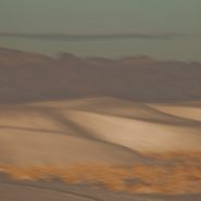
2011
The White Sands National Monument, located 300 miles south of Santa Fe at the northern end of Mexico’s Chihuahuan Desert, is nestled in the high-desert Tularosa Basin (4,200′ el.). Between the San Andres Mountain Range, to the west, and the Sacramento Mountains to the east, are the astounding white-white wave-like gypsum dunes, that over millions of years have engulfed 275 square miles of desert, comprising the world’s largest gypsum dunefield.
Between enormous upheavals in the Earth’s crust 250 million years ago, followed by the uplift of these mountains 150 million years later, these huge gypsum deposits were exposed. Rainfall and snowmelt then leeched out the gypsum, washing it down the mountainsides, to accumulate in Lake Lucero, the lowest point in the basin. Without outfall drainage, evaporation left behind layers of crystallized gypsum that prevailing southwest winds have carried up the basin, piling them in dunes as high as 50 feet.
Sand dunes are always striking as their organic shapes and patterns constantly change the absorption and reflection of light, but snow-white dunes are even more unique. Unlike most quartz desert sands, glistening white sands are composed of gypsum and calcium sulphate; also, unlike most beaches, white sand is cool to the touch, due to the high rate of evaporation of surface moisture, since the sand reflects rather than absorbs the sun’s rays.
This first series of images were captured shooting west as last light approaches; while in my next blog are of images shooting east, capturing early light. Equally fascinating is how low-angled winter light casts diverse color on the bright white gypsum sand. Shadowed low and flat light creates a bluish cast when shooting west toward last light, while early light casts an orange glow on the gypsum sand.


2016
Images from these last four series represent my fourteen year (so far) quest to convey my impressions of the Bosque del Apache, as Sandhills course through dimly-lit high desert winter skies, to-and-from the wetlands, during a 3 to 4 month period each winter.


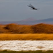
2016
At higher elevation, the brisk, late-light winter air barely illuminates the ever-so-quiet wetlands tapestry for the arrival of incoming migrating water fowl in the lee of the mountains to the west.
Ten to fifteen thousand mildly honking, considerably larger Sandhill Cranes follow in the wake of the tens of thousands of smaller but much more cacophonic snow geese…
And as the very last light descends, the wetlands regain their peacefulness — until the next morning’s very first light!


2012
During the coldest winter months, the Bosque del Apache’s diurnal rhythms are unbelievably consistent. At very first light the tremendous flocks of Snow Geese begin stirring, before rising in louder and larger groups that nearly blank out the sky, heading for adjoining grain fields to feed for the day; it’s only when no other creature can withstand the deafening din (transfering this bucolic scene into complete chaos), that the 12,000-to-15,000 Sandhills rise in smaller groups to also feed in the adjoining fields.
And then as the setting sun begins dropping behind the near western mountains, the enormous flocks of Snow Geese return, circling the wetlands before settling in for the night, followed more gradually by the larger, more majestic, and quieter Sandhills…


20XX
Following almost a month in Eastern Europe, I’m so glad to be back home in New Mexico’s high country, above 4,000′ elevation, which includes much of central and western New Mexico.
Always exhilarated by high-desert light, I’m starting off this year’s postings by re-visiting images of my favorite New Mexico locations, beginning with the Bosque del Apache National Wildlife Refuge, which is fed by the Río Grande, 150 miles south of Santa Fe. Established in 1939, this is a protected migratory stop for thousands of snow geese and upwards of 15,000 Sandhill Cranes heading south in November, then returning north beginning in February for breeding season.
Early winter light warms the soft wetlands screened by the 7,000′ Chupadera Mountains immediately to the west; as the sun clears the mountains, thousands of Snow Geese’s cacophony builds until the Sandhills too, with their six-foot wingspans, begin to lift off in twos and threes, heading for the nearby grain fields to feed for the day before returning, as the sun sets, to the wetlands’ 2-4′ of water.
So, this will be the first of the 4 Bosque del Apache favorites.


2016
Ninety minutes west of Calgary, Banff & Lake Louise begins Alberta’s spectacular 150 mile Icefields Parkway drive from Banff north to Jasper — ranked by National Geographic as one of the top 10 drives in the world. Certainly the most dramatic in Canada, it parallels the Continental Divide and the Columbia ice fields at an elevation of about 6,000′ through the magnificent Canadian Rockies.


2015
From 20 miles north of Santa Fe, my third and final series of the west face of the Sangre de Cristo mountain range. President Clinton was fond of saying, “its the economy stupid!”
Well, in photography, it’s all about the light…
On this day, the sun was “out full bore,” and because my captures were slightly earlier in the day, the sun still cleared the Jemiz Mountain range behind me; sunlight shined directly on Santa Fe Baldy, the highest peak in this section of the range. Blending the highlighted west face amongst its shadowed surroundings offered a very different series of compositions.


2015
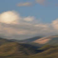
Another series of captures from “my” 8,500′ ridge vantage point, 20 miles north of Santa Fe, offers dramatic “takes” of the Sangre’s west face — including its foothills — leading up to its 12,000′ peaks perched under a late afternoon sky.
As direct sunlight still bathes the nearby foothills, the receding Sangre peaks read as a distant blue line of demarcation that separate the Blood of Christ ridge from the Western cloud-laden sky. These three receding horizontal elements of color and texture afford an array of blending possibilities…


2015
Returning to one of my favorite New Mexico palettes — just twenty miles north of my home in Santa Fe — an accessible 8,500 foot ridge offers unobstructed views across the 2-3 mile wide valley directly into the entire west face of the Blood of Christ mountain range, from its foothills all the way up and beyond its 12,000′ peaks, which are so often crowned with a continuously-modulating cloud cap as the evening light descends.
An always-varying palette of color, shadow, texture and form…


2015
Hong Kong began in the 1800s as a small fishing village, but gained importance as a port of transfer when the British began shipping opium to China. During the First Opium War (1839-42), it became a British colony with the cessation of Hong Kong Island in 1841, followed by the Kowloon Peninsula in 1860, and a 99-year lease of the New Territories in 1898.
Hong Kong and its 260 territorial islands are situated in the South China Sea, at the mouth of the Pearl River Delta. It is comprised of three main territories – Hong Kong Island, Kowloon Peninsula, and the New Territories – all of which were peacefully handed back to China in 1997. In 2009, Hong Kong was deemed a special Administrative Region (SAR) of China, abiding by the credo “one country, two systems.”
The name “Hong Kong” literally means “fragrant harbour”, emanating from the area around present-day Aberdeen at the south end of Hong Kong Island where fragrant wood products and incense were once traded. Victoria Harbor, the narrow body of water separating Hong Kong Island and Kowloon Peninsula, is renowned for being one of the deepest natural maritime ports in the world.
Hong Kong’s impressive skyline houses a current population of 7.4 million and boasts the second largest number of hi-rises of any city in the world.
Although suffering from much of the pervasive air pollution of mainland China, Hong Kong is blessed with sufficient ocean breezes to allow it a fair amount of direct sunlight and therefore visual contrast.


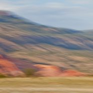
2014
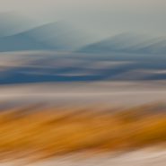
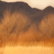
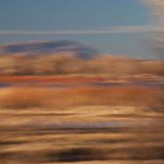
This is the third and final series of the Ortiz Mountains. In each of these images, I have stroked the camera ‘with the grain,’ while simultaneously also stroking ‘cross-grain;’ the resultant complex-curve pans, enable me to add depth and volume to these images which I like to think of as my own single-frame ‘Virtual Realities.’


