2007
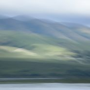
Tomales Bay
Tomales Bay, a 15 mile long by mile wide inlet of the Pacific Ocean, separates Point Reyes Peninsula from the Marin County mainland, 30 miles north of San Francisco. The bay forms the eastern boundary of Point Reyes National Seashore and lies along a submerged portion of the San Andreas Fault.
On its northern end, Tomales Bay opens out onto Bodega Bay, which shelters it from the direct current of the Pacific.
Nestled between the Marin hills to the east and the Point Reyes Peninsula’s rolling hills to the west, this tranquil bay offers lovely views of the edges of these two land masses.


Read More
2007
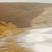
Drakes Bay
Thirty miles north of San Francisco, southwest facing Drakes Bay is situated on the lee side of the southern coastal current of Point Reyes Peninsula. Long considered Drake’s most likely landing spot on North America’s west cost during his 1579 world circumnavigation,
Drakes Bay is backed by dramatic white sandstone cliffs that were created 10-13 million years ago. Erosion has revealed the striations of this story in the cliff faces.
The constant pounding of the Pacific combined with the magnificent 8-mile curved Bay’s tempestuous weather emphasizes the incessant passage of time.


1999
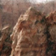
Western Space + Time
Having awakened my appetite for large-scale landscape, I explored other western vistas in Wyoming, Utah, California and northern Arizona, in addition to return visits to the high country of Montana. Experimenting with the panoramic format, I found it easier to capture the breadth of the land while more closely matching its flow.
During the creation of this series, I first realized that my obsession with condensing time via motion within a single frame was intimately linked to a lifetime of restlessness.


1997
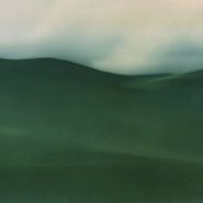
Needing an escape from urban living, I spent weeks in the solitude of Montana’s incredible high-country where I first experienced the grandeur of western landscape. It’s grand distances, unavailable in the Washington, DC parks, opened up a host of new possibilities in light, color and resolution that took me to a place I hadn’t experienced since the transatlantic ocean sailing days of my early twenties.


