2013
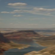
The Green River is both the inflow and outflow of Flaming Gorge Reservoir, whose elevation when full is 6,040′. Created in 1964 by the completion of the Flaming Gorge Dam, the reservoir is mostly situated in Wyoming, as its northern tip is only 14 miles southwest of Rock Springs, WY. Just its southern end dips into northeastern Utah.
Rising out of western Wyoming’s Wind River Mountains, the Green River is the principal tributary of the Colorado River. During John Wesley Powell’s 1869 expedition down the Green River, he named the Flaming Gorge for its spectacular red sandstone cliffs surrounding this part of the river. The Green River continues south through Utah, before it merges with the Colorado River 40 miles into western Colorado.


Read More
2011
“It is not a country of light on things. It is a country of things in light.”
—Georgia O’Keefe
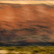
An hour north of Santa Fe, begins a landscape of vast vistas, flat-topped mesas, and tall cliffs with winding rivers bordered by huge old cottonwood trees. Ghost Ranch lies in the broad shallow Chama Basin along the eastern margin of the Colorado Plateau as it transitions toward the Rio Grande Rift further east. Occupying parts of New Mexico, Arizona, Utah and Colorado, the Colorado Plateau has been a relatively stable block in the Earth’s crust for at least 600 million years; consequently the rocks around Ghost Ranch are generally flat-lying and less mildly deformed by broad-scale folding.
The oldest rocks exposed in the Ghost Ranch area belong to a thick package of brick-red to red siltstone and mudstone and white to tan sandstone, deposited by rivers more than 200 million years ago when the Ghost Ranch area was located about 10 degrees north of the equator.
In 1929, painter Georgia O’Keefe first began working part of the year in northern New Mexico, which she made her permanent home in 1949. Between 1929 and 1949, she spent part of nearly every year working in New Mexico. Then in 1934 she first visited Ghost Ranch, north of Abiquiu and decided immediately to live there.
Ghost Ranch’s varicolored cliffs inspired some of her most famous landscapes. “The cliffs over there are almost painted for you – you think – until you try to paint them.” O’Keefe wrote in 1977. “Such a beautiful, untouched, lonely feeling place, such a fine part of what I call the ‘Faraway’. It is a place I have painted before…even now I must do it again.” So how can I resist painting this same landscape with my camera, using the foil of time to render my own interpretation?
To view more images of Ghost Ranch, see Ghost Ranch II and Ghost Ranch III.


Read More
2011
One hundred miles south of the Grand Canyon, Sedona sits in front of the Mogollon rim’s 50 million years of exposed sedimentary layering that evidences the formation of the Colorado Plateau 250 million years ago.
To experience first or last light among its red rocks reveals why Sedona has taken on its own spiritual aura. The red Sandstone and tan mudstone coupled with the immediacy of the formations are breathtaking.


Read More
2007
Drakes Bay
Thirty miles north of San Francisco, southwest facing Drakes Bay is situated on the lee side of the southern coastal current of Point Reyes Peninsula. Long considered Drake’s most likely landing spot on North America’s west cost during his 1579 world circumnavigation,
Drakes Bay is backed by dramatic white sandstone cliffs that were created 10-13 million years ago. Erosion has revealed the striations of this story in the cliff faces.
The constant pounding of the Pacific combined with the magnificent 8-mile curved Bay’s tempestuous weather emphasizes the incessant passage of time.


2007
Driving West to the Grand Canyon from Santa Fe, five miles east of the Continental Divide, at 7,200’ elevation, the sun’s low angle dramatically rakes the south face of the Colorado Plateau’s sandstone cliffs.


