2013
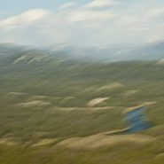
The Snake River’s headwaters are formed at the consolidation of three tiny streams, at an elevation of nearly 9,000′, on the southwest flank of Two Oceans Plateau situated in western Wyoming’s portion of Yellowstone National Park.
Flowing south through Jackson Lake, the ninth longest river in the US continues on south through Jackson Hole valley between the Tetons and Wind River Range, before making a large western sweep through southern Idaho’s Snake River Canyon, and then northwest through Oregon and Washington, where it becomes the Columbia River’s largest tributary, as well as the largest North American river to empty into the Pacific Ocean.
Looking east from the Tetons – the Snake continues its 1,078 mile journey to the Pacific — between the Tetons and The Wind River Range — as it flows south through Jackson Hole.


2011
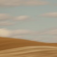
Known for its picturesque, steep, undulating hills, ‘The Palouse’ encompasses the Palouse River watershed rising west out of north-central Idaho’s Blue Mountains to southeastern Washington State, where it turns south emptying into the Snake River.
The unique Palouse region was formed 30 million years ago as the Pacific Plate was pushed beneath the North American Plate, creating a chain of volcanoes that forced molten rock to erupt from cracks in western Oregon’s and Washington’s crust to form the Columbia Plateau basalts. Twenty million years later, the modern Cascade Range lifted up. Two million years ago, glaciers scoured the Pacific NW, generating volcanic silt (“loess”). Prevailing SW winds covered the Palouse’s lava floor with dunes as high as 200’ of wind-blown volcanic silt, resulting in the most fertile land in the northwest.
Lush grasslands provided prime winter grazing for the Nez Perce Indians’ painted ponies, the Appaloosas, until dry land farmers overran this land in the 1880’s. Contour-farming this fertile land for wheat and lentel beans, as high up the slopes as machinery allowed, the varying “painted” shapes have since traced these contours with the seasons’ beautiful patchwork.
Even more visually intriguing than from ground level, this landscape viewed from an isolated 1,000’ high quartzite ‘hill’, Steptoe Butte, offers spectacular aerial views of the Palouse hills.


Read More