2013
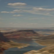
The Green River is both the inflow and outflow of Flaming Gorge Reservoir, whose elevation when full is 6,040′. Created in 1964 by the completion of the Flaming Gorge Dam, the reservoir is mostly situated in Wyoming, as its northern tip is only 14 miles southwest of Rock Springs, WY. Just its southern end dips into northeastern Utah.
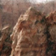
Rising out of western Wyoming’s Wind River Mountains, the Green River is the principal tributary of the Colorado River. During John Wesley Powell’s 1869 expedition down the Green River, he named the Flaming Gorge for its spectacular red sandstone cliffs surrounding this part of the river. The Green River continues south through Utah, before it merges with the Colorado River 40 miles into western Colorado.


Read More
2013
Another Rocky Mountain range in Western Wyoming, The Winds run generally NW-SE for about 100 miles, and include more than 40 peaks in excess of 13,000′. Gannett Peak, at 13,809′ is the highest mountain in Wyoming, though only 33′ higher than the 13,776′ Grand Teton. Except for Grand Teton, the next 19 highest peaks in Wyoming, are in The Winds. Two National Forests and three wilderness areas encompass most of the Wind River Range, as the Continental Divide follows its crest.
Shoshone National Forest on its east side, and Bridger-Teton National Forest to the west, and the entire Wind River range, are all part of the Greater Yellowstone Ecosystem. Portions of the range are also within the Wind River Indian Reservation.
Indigenous peoples of the Great Basin, such as the Shoshones and Absarokas (Crow) Native Americans lived in the range beginning 7,000 and 9,000 years ago.


2013
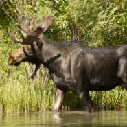
Moose, distinguished by the males’ palmate antlers, which can have up to a 6 foot spread, are the largest extant species in the deer family. Except for the two species of bison, the moose is the second largest land animal in both North America and Europe. Typically they inhabit boreal and mixed deciduous forests of the Northern Hemisphere in temperate to subarctic climates. While Moose used to have a much wider range, hunting and other human activities have greatly reduced it.
The most common moose predators are wolves, bears, and humans. Unlike most other deer species, moose are solitary animals and do not form herds. Although generally slow-moving and sedentary, moose can become aggressive and move quickly if angered or startled. Their mating season in the autumn can lead to spectacular fights between males competing for a female.
Right out of ‘central casting’, this bull moose poses in all his glory along the edge of a good friend’s front yard pond fed from the Snake River.


2013
The Snake River’s headwaters are formed at the consolidation of three tiny streams, at an elevation of nearly 9,000′, on the southwest flank of Two Oceans Plateau situated in western Wyoming’s portion of Yellowstone National Park.
Flowing south through Jackson Lake, the ninth longest river in the US continues on south through Jackson Hole valley between the Tetons and Wind River Range, before making a large western sweep through southern Idaho’s Snake River Canyon, and then northwest through Oregon and Washington, where it becomes the Columbia River’s largest tributary, as well as the largest North American river to empty into the Pacific Ocean.
Looking east from the Tetons – the Snake continues its 1,078 mile journey to the Pacific — between the Tetons and The Wind River Range — as it flows south through Jackson Hole.


2013
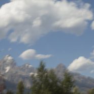
The Rocky Mountains’ north-south Teton Range includes 9 peaks in excess of 11,000′ elevation, with Grand Teton being the highest at 13,770′. Beginning just south of Yellowstone National Park, the Teton Range is situated primarily on the Wyoming side of the state border with Idaho, with most of the range’s east slope located in the Grand Teton National Park.
This area, 2.5 billion years ago, was an ancient ocean that gradually filled with sand and volcanic debris. As additional sediment deposited over millions of years, heat and pressure metamorphosed this sediment into gneiss, until eventually magma was forced up through the cracks in the gneiss to form granite, anywhere from inches to hundreds of feet thick.
Then, 6-10 million years ago, stretching and thinning of the Earth’s crust caused movement along the Teton fault: as the fault line’s west block rose to create the Teton Range – the youngest of the Rocky Mountains — the fault’s east block collapsed forming the valley called Jackson Hole.
While the west side of the Teton Range appears as high rolling hills transitioning smoothly into flat pasture, the Teton’s spectacular east-facing granite slope — too young to have eroded into soft hills, and without lower peaks to obscure it — rises dramatically 5,000 to 7,000′ above the valley floor.


2013
Originally referred to as the East Fork of the Yellowstone River, the 40 mile long Lamar River rises out of the Absaroka Range along the eastern border of Yellowstone National Park, and meanders northwest and then west to where it flows into the Yellowstone River south of the Montana Border. The wide, expansive Lamar Valley is home to bison, elk, coyote, grizzly and wolf.
In 1995, wolves were re-introduced in the northeast corner of Yellowstone Park along the Lamar River at Soda Butte, Crystal Creek and Rose Creek.


2013
The Absoraka-Beartooth Wilderness Area contains 30 peaks above 12,000′ elevation. As an integral part of the 20 million acre Greater Yellowstone Ecosystem, it borders Yellowstone National Park’s eastern side, straddling the Wyoming-Montana line and encompassing two distinct mountain ranges: the Beartooth Mountains, named after the likeness between a jagged mountain peak in the range and a bear’s tooth; and the Absorakas, named after the Crow Indians (Absoraka being the Indian name for crow).
Along the eastern side of the wilderness area, The Beartooths have the largest unbroken area of land within the lower 48 states in excess of 10,000 feet elevation. Comprised almost entirely of beautiful but fragile, high, treeless, bald granite plateaus interspersed by glacial lakes, the Beartooths include Montana’s highest mountain, the 12,799′ Granite Peak.
North of the Beartooths lies the Absaroka range’s stratified volcanic rocks, forested valleys and rugged peaks forming a chain of mountains that includes spectacular peaks east of Paradise Valley, beginning in Wyoming, including the Absoraka’s highest mountain, Francs Peak (13,153′), and continuing north into Montana.
Heading west from Red Lodge, Montana, (5,500′), US Route 212 goes up, down, and up again, for 70 incredibly tortuous miles along the Montana-Wyoming Border through the Beartooths; winding south into Wyoming just before the 10,947′ Beartooth Pass, (the highest road in the northern Rockies) and then back north into Montana over the 8,100′ Colter Pass, through Cooke City (6,400′), and finally climbing to Yellowstone’s NE entrance at 7,500’ elevation, once again in Wyoming.
The views along the Beartooth Pass are spectacular and unnerving. Whether the high tundra mountain tops, or deep down in the incredibly steep valleys, the views are difficult to fathom.


1999
Western Space + Time
Having awakened my appetite for large-scale landscape, I explored other western vistas in Wyoming, Utah, California and northern Arizona, in addition to return visits to the high country of Montana. Experimenting with the panoramic format, I found it easier to capture the breadth of the land while more closely matching its flow.
During the creation of this series, I first realized that my obsession with condensing time via motion within a single frame was intimately linked to a lifetime of restlessness.


1997
Needing an escape from urban living, I spent weeks in the solitude of Montana’s incredible high-country where I first experienced the grandeur of western landscape. It’s grand distances, unavailable in the Washington, DC parks, opened up a host of new possibilities in light, color and resolution that took me to a place I hadn’t experienced since the transatlantic ocean sailing days of my early twenties.


