2016
West of San Miguel de Allende, the Laja River rises in the Sierra Madre at about 6,000′ elevation, arches east and then south through the central plateau, past San Miguel de Allende, where it flows into the Lerma River.
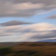
Looking east 15 miles to San Miguel across Presa Allende Lake — created by the Ignacio Allende Dam to control Laja River flooding — offers a wonderful sense of Mexico’s central plateau high desert landscape.


2016
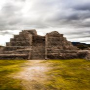
Fifteen miles west of San Miguel de Allende, situated on a small mesa surrounded by canyons, the Canada de La Virgen Pyramid was occupied between 500 and 1000 a.d. by the Otomi people, one of the many indigenous ethnic groups of the Middle American Indian population that inhabited the central plateau region of central Mexico.
The House of the Thirteen Heavens — which served as a horizon clock, an observatory, and a burial ground for the elite — was in perfect alignment with the sun, the moon, and all but one of the planets in our solar system at sunset during the Otomi New Year’s Eve, March 4, 2011, while the missing planet, Saturn, was situated precisely 180 degrees from the setting sun, just at the visual beginning of the ritual causeway to the site.
The interplay of the pyramid’s various-sized wall stones reflects the meticulous layout and care of the construction of this pyramid complex begun more than 1,000 years ago.


Read More
2016
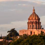
Often likened to our very own Santa Fe, the small colonial city of San Miguel de Allende — 170 miles NW of Mexico City — was founded as “San Miguel” in 1542 by a San Franciscan monk, San Miguel El Grande. After it became the centerpiece in the war for Mexican independence from Spain, it was renamed San Miguel de Allende after Ignacio Allende, a hero of the independence movement.
This small city of 80,000 — situated along the Grand Plateau of Mexico, at 6,000+ feet elevation, between the eastern and western branches of the Sierra Madre Mountains — still thrives as the economic and cultural soul of Mexico. Spanish conquistadors ruled while the great colonial cities of Guadalajara, Morelia, Queretaro, Mexico City and Pueblo evolved during the Spanish silver mining era, later playing pivotal roles in the Mexican fight for independence.
Situated on a steep hill, San Miguel’s El Centro opens onto a lovely plaza surrounded by wonderfully colorful facades amongst numerous exceptional churches. It’s narrow cobblestone streets complete its nearly 500 year history, preceding Santa Fe’s recently celebrated 400 year colonial history as our oldest state capital (founded in 1610, also by Spanish colonists). Although Santa Fe is 1,000′ higher than San Miguel, both benefit from year-round moderate temperatures and exceptional high desert light.


