2012
Jutting south 150 miles from the southern coast of Alaska, the Kenai Peninsula – derived from Kenayskaya, the Russian name for Cook Inlet — is separated from the mainland on the west by Cook Inlet, and on the east by Prince William Sound. Athabaskan and Alutiiq Native groups have lived on the peninsula for thousands of years.
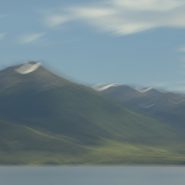
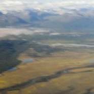
The glacier-covered 7,000′ high Kenai Mountains run down the southeast spine of the peninsula along the coast of the Gulf of Alaska. Kenai Peninsula’s two principal towns are Seward, located on the east coast on the Gulf of Alaska, while Homer, situated on Kachemak Bay, lies along Cook Inlet on the peninsula’s west side.
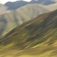
As the glaciers recede on the Kenai Mountains, various stages of gradual re-growth of these denuded mountains provide classic views of very gradual stages of faint green.
After two days of completely socked-in weather in and around Seward, we drove back north, then west across the peninsula, where the weather broke for about a half day, as we headed south allowing visibility along Cook Inlet, Kachemak Bay, and the town of Homer.
With the weather forecasts now calling for continuous clouds for at least another week, we departed Homer and headed back to Anchorage and boarded a return flight to New Mexico a week early.


2012
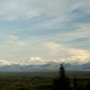
The Chugatch Mountain Range is the most northern of the mountain ranges comprising the western edge of North America. Approximately 250 miles long by 60 miles wide, it extends from the Turnagain Arm at the north end of Cook Inlet, where it bends southeast just south of Anchorage.
Mount Marcus Baker’s 12,884′ elevation is the highest point in the Chugatch Range, which includes 9 mountains above 10,000’ elevation. Situated along the Gulf of Alaska, the very moist air generates more than 600 inches of snow annually — more than anywhere else in the world.
Driving northeast on Alaska A1 (Glenn Hiway) from Wasilla provides stunning views of the northern side of the Chugatch Range, including the Matnuska Glacier.


2012
Now that we had flown over the Peter’s Hills to the beginning of Denali’s vertical ascent, in and around this incredibly steep range, landed on and taken off from a glacier, circled the northern side of Denali, and returned the 60 miles back to Talkeetna, the challenge was to capture the entire Denali Mountain from afar. And luck was with us, as it was clear as a bell!
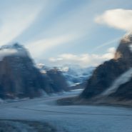
The Alaska Range is the highest in the world outside of Asia and the Andes. It forms a generally east-west arc with its northernmost portion in the center. Acting as a high barrier to the flow of moist air from the Gulf of Alaska northwards, The Alaska Range has some of the harshest weather in the world.


2012
Flying in and landing on a glacier is exciting. Equipped both with wheel landing gear and with skis that can be lowered below the wheels from the cockpit, the pilot’s greatest concern is maintaining depth perception against the ice’s glare.
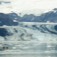
Ruth Glacier, Denali’s largest, appears to be an interstate, with numerous smaller glaciers feeding into it much like interchanges. Very deceptive from the air, the glacier’s center line is actually a crevice, which on larger glaciers is very wide and often extremely deep, posing much difficulty for climbers to span.
Meanwhile, Ruth Glacier is continuously sliding down the mountain at a rate of about 3 meters per year.


2012
Flying to Anchorage, we rented a car and drove 100 miles north to the old mining town of Talkeetna, where its airfield has become the climber’s gateway to the Alaska Range sixty miles east.
The dominant peak, of course, is Mt. McKinley, also called Denali, the Athabascan name for The High One. At 20,320′, it is the tallest mountain in North America, and since it is situated nearly at sea level, its 18,000′ vertical ascent is the highest of any mountain in the world. Plus, being located at the furthest northern latitude of any major mountain range on Earth, it is also among the coldest and windiest places on Earth!
Flying into the Alaska Range, we landed on the same glacier where two weeks earlier seven Japanese climbers were delivered to begin their ascent. Viewing this mountain from above, it is little wonder, albeit tragic, that only one of the seven survived.
Yet as it was a clear day, our flight to Denali was just spectacular. It is said that only about one third of the people who visit Alaska ever see the top of the Alaska Range. What luck, as we had good weather for three consecutive days.


Read More
2012
For three days of our Alaskan cruise, we explored from inflatable zodiacs and climbed on numerous glaciers within Glacier Bay — including John Hopkins, Lamplugh, Margerie, and Rendu — seeing many humpback whales, an Orca Whale pod and numerous Sea Otters.
With sunny, clear weather, the glacier blue ice was beautiful. Studying ship-board maps, the up-close and memorable effects of climate change are now indelibly fixed.
Upon exiting Glacier Bay via Lynn Canal, we sailed to our final stop in Juneau, where we disembarked.
A fascinating side note: since my next door neighbor in Santa Fe’s last name is Rendu, I enquired if he had any connection to the Rendu Glacier. Upon researching, he learned that a great, great uncle was a Jesuit Priest who spent a number of years in Alaska, and it was he who Rendu Glacier was named after.


2012
Arriving from Seattle, we flew into Sitka, Alaska in mid-August, about midpoint up the Alexander Archipelago that separates the mainland from the Pacific Ocean. Southeast Alaska’s 1,000 forested islands, 10,000 miles of shoreline, and 50+ major glaciers, have changed little in the past 1,000 years, except for the addition of slightly more than 70,000 residents. A temperate, hospitable land, the rain forest provides a cool environment most of the year. Transportation among the islands is still by water, though access to Alaska’s capitol in Juneau is essentially only by air.
Two days later we embarked on an 8-day cruise through the northern Inner Passage, aboard a 150′ vessel with 50 passengers plus crew. Exiting past the beautiful Mt. Edgecomb volcanic island, we rounded the northern end of Baranoff Island, then headed southeast out Peril Strait where we turned northeast up Chatham Strait.
It was so exciting to finally be cruising Alaska’s storied Inside Passage up to Glacier Bay!


