2014
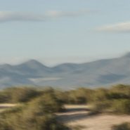
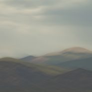
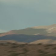
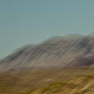
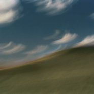
A while back, I had the opportunity to ‘house-sit’ for friends who live on a ridge overlooking the Ortiz Mountains in the southern quadrant of Galisteo Basin, twenty miles south of my home in Santa Fe. Three weeks of this particular view gave me the opportunity to pursue different visual themes of the Ortiz: more or less straightforward photographic capture, plus overlaying the scene with varying motion strokes to stretch, and cross-cut the scene; and then to incorporate dramatic first and last New Mexico light to once again re-integrate my strokes.


2014
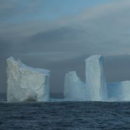
Antarctica – the most extreme place on Earth!
Colder and windier than anywhere else on our planet, nothing has melted there in 40 million years; drier than anywhere else on Earth, though covered with 90% of Earth’s fresh water (as ice); the fifth largest continent on Earth has the highest average elevation as it is covered with 5,000 feet of ice.
Situated at the bottom of the Earth, beginning 500 miles south of the southern tip of South America, it spans the South Pole, where it is completely surrounded on all sides by some of Earth’s most treacherous oceans.
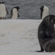
The only warm-blooded creatures that can live there year-round, are penguins, plus a few scientists.
As global warming continues, glaciers larger than small countries along both it’s southwestern and eastern edges, have now begun calving. not if, but when just half of this calving ice melts completely over the next 50 years, Earth’s sea level will rise more than 25 feet!
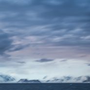
Uninhabitable as the Antarctic continent is, it is so very beautiful: white ice and snow covers the entire continent (except where the rock is so vertical that ice can not cling to it) against its backdrop of roiling oceans filled with thousands of smaller chunks of ice. When the weather is clear, the light is piercingly bright, casting long shadows against the surrounding ocean.


2014
Fur Seals and Whales are widely distributed in the Southern Ocean within the Antarctic Convergence – the zone of water between the frigid waters of the true Antarctic and more temperate waters to the north. Most of the Fur Seal population breeds on South Georgia Island, and other nearby sub-Antarctic islands.
Fur Seals average 6-7 feet in length and weigh 200-250 pounds, and up to 400 lb. for the males. Their diet includes krill, squid and fish. The males tend to live about 15 years, while females live to 25 years on average. Antarctic Fur Seals are an example of seals that can walk on land, because of their ability to turn their rear flippers forward, converting them into useful “feet”.
Generally Fur Seals are a solo act outside of mating season although they will congregate in vast numbers on beaches near good feeding grounds in the autumn and early winter, often near penguin colonies. Breeding season begins in late October through December. Males fight extremely aggressively, with some encounters resulting in death, for the right to rule harems of up to 20 females (who wouldn’t?). Once they’ve established a harem, males are unwilling to leave them unprotected and will stay on land for up to 2 months without feeding. When the females arrive they are already pregnant from the previous year’s season, and give birth in November and December. The females mate about a week after giving birth. The pups are nursed by their mothers for about 4 months. Once they have learned to swim they usually stay at sea a number of years until they reach sexual maturity, at which point they return to land to join the others during the mating season.
Fur Seals’ natural predators are Sharks and Killer Whales, while the pups are vulnerable to Leopard Seals.
Whales most commonly found in the Southern Ocean are Humpback, Fin, with lesser numbers of Blue Whales. They are after the tremendous schools of high-protein krill.
Though I didn’t get to witness this, Orcas are known to hunt in packs, seeking out Fur Seals on small icebergs. Surrounding the iceberg, they repeatedly swim under it in unison, until the iceberg either tips, or breaks up as a result of the vibration created by the Orcas, at which point they grab the Fur Seal.
Fur Seals, when on shore, are readily visible; they often hang out near penguin colonies. Whales, on the other hand, are generally visible only at greater distances, or occasionally when they happen to surface very close.


2014
Nothing has melted on Antarctica over the last 40 million years! The Earth’s fifth largest continent, including the South Pole, is its coldest, windiest, and driest continent. Since nothing melts on Antarctica, today it contains 90% of all of the Earth’s ice. Over these millions of years, the ice sheet has accumulated to more than a mile in height, making Antarctica the earth’s highest continent, with an average elevation greater than 5,000′.
Because of such minimal precipitation, however — only 2″ per year in the interior — Antarctica is considered desert. While its coastal regions receive 8″ of falling moisture annually, unlike most desert regions, frozen moisture can’t soak into the ground, so it too, adds to the ice sheet.
Stretching diagonally northwest-to-southeast nearly 2,000 miles across Antarctica, the Transantarctic Mountain Range (Mt. Kirpatrick, 14,856′ elev.) separates the continent’s east and west regions. Two thirds of Antarctica, lying east of this mountain range, is the size of Australia, while the western third includes a series of frozen islands comprising the Antarctic peninsula – which originally was a continuation of the Andes Mountain Range.
The ice sheets covering Antarctica slowly migrate: glaciers inch across the continent, cracking and breaking. As ice sheets crack along the coast, ice shelves and glaciers break off into the sea as icebergs.


2013
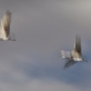
Each morning during their migration rest at Bosque del Apache, the Sandhill Cranes rise from fields flooded by 2-3 feet of water, where they are safe from predators. In groups of 3 to 10 they fly to nearby grain fields, where they spend the day feeding, only to rise again as the day fades and return to the safety of the wetlands for the night.
Weighing 8 to 10 lbs. and with a wingspan of up to 6 feet, Sandhills look ungainly while standing, but stretch into beautiful aerodynamic form with their powerful pumping wings slowly lifting them into the sky


2013
Beginning just south of Bozeman, MT, the Rocky Mountains’ north-south Gallatin Range, including 10 mountains above 10,000′ elevation, extends south 75 miles, averaging 20 miles wide, into the northwestern section of Yellowstone National Park. The Gallatin River flows north threading through Gallatin Valley. Opposite Gallatin Range, along the west side of the Gallatin Valley is the Madison Range. Along the eastern edge of the Gallatin Range the Yellowstone River flows north through Paradise Valley.
About midway between Gallatin Gateway and Yellowstone Park is the Big Sky ski resort situated in the Madison Range on 11,161′ Lone Mountain.
As US 191 heads south from Bozeman, the Gallatin Valley narrows dramatically as it begins to wind between the Gallatin and Madison ranges. Along the east side of Gallatin Valley, its foothills climb east up the Gallatin Range, while to the west Ted Turner’s 113,000 acre Flying D Ranch lies against the spectacular Spanish Peaks sub-range to the south, with its 11,015′ Gallatin Peak, and stretches from the Gallatin River west over the Madison Range to the Madison River at Ennis.
Gallatin Gateway is where the Gallatin Valley narrows to wind between the Gallatin and Madison ranges; a dear friend’s lovely ranch, perched on a south facing bench, provides wonderfully picturesque views of the melding of these three mountain ranges.


2013
The Absoraka-Beartooth Wilderness Area contains 30 peaks above 12,000′ elevation. As an integral part of the 20 million acre Greater Yellowstone Ecosystem, it borders Yellowstone National Park’s eastern side, straddling the Wyoming-Montana line and encompassing two distinct mountain ranges: the Beartooth Mountains, named after the likeness between a jagged mountain peak in the range and a bear’s tooth; and the Absorakas, named after the Crow Indians (Absoraka being the Indian name for crow).
Along the eastern side of the wilderness area, The Beartooths have the largest unbroken area of land within the lower 48 states in excess of 10,000 feet elevation. Comprised almost entirely of beautiful but fragile, high, treeless, bald granite plateaus interspersed by glacial lakes, the Beartooths include Montana’s highest mountain, the 12,799′ Granite Peak.
North of the Beartooths lies the Absaroka range’s stratified volcanic rocks, forested valleys and rugged peaks forming a chain of mountains that includes spectacular peaks east of Paradise Valley, beginning in Wyoming, including the Absoraka’s highest mountain, Francs Peak (13,153′), and continuing north into Montana.
Heading west from Red Lodge, Montana, (5,500′), US Route 212 goes up, down, and up again, for 70 incredibly tortuous miles along the Montana-Wyoming Border through the Beartooths; winding south into Wyoming just before the 10,947′ Beartooth Pass, (the highest road in the northern Rockies) and then back north into Montana over the 8,100′ Colter Pass, through Cooke City (6,400′), and finally climbing to Yellowstone’s NE entrance at 7,500’ elevation, once again in Wyoming.
The views along the Beartooth Pass are spectacular and unnerving. Whether the high tundra mountain tops, or deep down in the incredibly steep valleys, the views are difficult to fathom.


2013
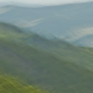
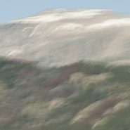
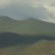
The fourth of ten successive explorations of the Santa Fe Baldy portion of the Sangre de Cristo range, just north of Santa Fe.


2013
This is the third of my ten successive explorations of the Santa Fe Baldy portion of the Sangre de Cristo range, just north of Santa Fe. Captured with slightly earlier afternoon light, filtered with some cloud cover, the lower contrast of these images offers a closer examination of the blended hues of the foothills against the ridge lines.


2013
Returning for the second time to my “new best” vantage point, just north of Santa Fe, to capture the Sangres surrounding Santa Fe Baldy, New Mexico’s 4th highest peak, this time at early light; “my ridge” first presents the sun breaking behind the peaks, before lighting up the early clouds in concert with the ridge lines.
I’m expecting that this extended exploration of the light’s effect on this same section of the Sangre peaks will provide me a narrow comparative study which I have not attempted before.


2013
Santa Fe, New Mexico’s capitol, lies along the western edge of the Sangre de Cristo (Spanish for Blood of Christ) Mountain Range, which is the most southern subrange of the Rocky Mountains. Twenty miles west of Santa Fe is the Jemez Mountain Range, with the Río Grande flowing south between the two…
Less than 20 miles north of Santa Fe is a stretch of the Sangres that includes the third and fourth highest mountains in New Mexico: Truchas Peak (13,108′) and Santa Fe Baldy (12,632′). With this section of the Sangres so close to Santa Fe and so visually accessible, I decided to do an extended study of the setting sun’s effect on these peaks during the spring and summer of 2013. My light exploration was optimally accessed by a ridge five miles west, which placed me at the upper edge of the foothills.
This vantage point allowed me to concentrate on the elements of this mountainous landscape — light, shadow, and form — while enabling me to blend these elements with the foothills, the peaks, and the sky in various combinations.
Each of the successive permutations also reflects a single capture spanning no more than an hour of New Mexico’s last light.


2013
Situated in New Mexico’s Tularosa Basin, between two 8-9,000′ mountain ranges — the San Andres Mountains to the west and Sacramento Mountains to the east —White Sands, unlike most desert sands made of quartz, is composed of gypsum and calcium sulfate. Unlike sand found on most beaches, white sand is cool to the touch, due to the high rate of evaporation of surface moisture and the fact that the sand reflects rather than absorbs the sun’s rays. At an average 4,000′ elevation, the estimated 275 square miles of White Sands’ dune fields is known as the world’s largest surface deposit of gypsum.
Equally fascinating is how low-angled winter light casts diverse color onto the bright white gypsum sand. Shadowed low and flat light casts blue when shooting west toward last light, while early light casts an orange glow on the gypsum sand.
This is my third visit to White Sands. Each time I see it differently, and each time I come away with images that greatly excite me. A little over a year ago I hung a show at Las Cruces Museum, eleven images from my three visits including three from this series.


2013
Stretching over 1,000 miles, the Rio Grande/Rio Bravo forms the international boundary between the United States and Mexico. Named for the southernmost 118 mile U-shaped bend in the Rio Grande, Big Bend National Park’s 1,250 sq. miles means it is larger than the state of Rhode Island.
Lying in a southwest – northeast axis, the 20 mile long Chisos Mountain range is the furthest southern mountain range in the U.S. Its 7,835′ Emory Peak is the highest of its four peaks that exceed 7,000′.
The Chisos Mountains, initially amongst a surrounding lowland formed some 66 million years ago, was uplifted 30 million years later. Followed by very active volcanism, the high basalt content offers a wide range of beautifully subtle hued formations.
I found I just couldn’t resist the texture, color and shape of the Chisos Mountains basalt formations…


2012
The Sangre de Cristo (Blood of Christ) Mountain range is the southernmost subrange of the Rockies; they begin in Southern Colorado and extend south to just below Santa Fe. At the north end of town, on the Sangre’s western slope is Santa Fe Mountain, whose west face is covered with very large Aspen stands.
Native to cold regions with cool summers at altitudes above 5,000 feet, aspens are medium-sized deciduous trees reaching as high as 100′. They generally grow in large colonies derived from a single seedling and spread by means of root suckers whose new stems may appear more than 100 feet from the parent tree. While each individual tree can live for 40 to 150 years, they send up new trunks as the older trunks die off above ground, so their root systems are long-lived, in some cases for thousands of years, which is why aspen stands are considered to be ancient woodlands.
Come the end of September through mid-October, the west face of Santa Fe Mountain lights up as the Aspen leaves turn their beautiful, riotous, yellow. Illuminated by the lower angle of fall sunsets, the light is just magical.


Read More
2012
Arriving from Seattle, we flew into Sitka, Alaska in mid-August, about midpoint up the Alexander Archipelago that separates the mainland from the Pacific Ocean. Southeast Alaska’s 1,000 forested islands, 10,000 miles of shoreline, and 50+ major glaciers, have changed little in the past 1,000 years, except for the addition of slightly more than 70,000 residents. A temperate, hospitable land, the rain forest provides a cool environment most of the year. Transportation among the islands is still by water, though access to Alaska’s capitol in Juneau is essentially only by air.
Two days later we embarked on an 8-day cruise through the northern Inner Passage, aboard a 150′ vessel with 50 passengers plus crew. Exiting past the beautiful Mt. Edgecomb volcanic island, we rounded the northern end of Baranoff Island, then headed southeast out Peril Strait where we turned northeast up Chatham Strait.
It was so exciting to finally be cruising Alaska’s storied Inside Passage up to Glacier Bay!


2013
The interior of Hawaii’s “Garden Isle”, cries out to be captured with panoramic composition. As the flowing lava built up and solidified over several million years, it formed subtle exaggerated layers, which turn increasingly abstract as the colors meld with the sky.
Oh, to have one’s own helicopter, or better yet, imagine what could be captured with a camera attached to one of the new quadcopter drones!


My first attempts at infusing the feeling of motion into my photographic images originated with my shooting moving objects – cars, trains, people walking or running. (more…)
Read More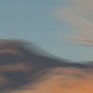
Looking at a book on Alaskan Totem Poles a few years ago got me thinking that totems were panoramics turned on their end. (more…)
Read More
2011
“It is not a country of light on things. It is a country of things in light.”
—Georgia O’Keefe
An hour north of Santa Fe, begins a landscape of vast vistas, flat-topped mesas, and tall cliffs with winding rivers bordered by huge old cottonwood trees. Ghost Ranch lies in the broad shallow Chama Basin along the eastern margin of the Colorado Plateau as it transitions toward the Rio Grande Rift further east. Occupying parts of New Mexico, Arizona, Utah and Colorado, the Colorado Plateau has been a relatively stable block in the Earth’s crust for at least 600 million years; consequently the rocks around Ghost Ranch are generally flat-lying and less mildly deformed by broad-scale folding.
The oldest rocks exposed in the Ghost Ranch area belong to a thick package of brick-red to red siltstone and mudstone and white to tan sandstone, deposited by rivers more than 200 million years ago when the Ghost Ranch area was located about 10 degrees north of the equator.
In 1929, painter Georgia O’Keefe first began working part of the year in northern New Mexico, which she made her permanent home in 1949. Between 1929 and 1949, she spent part of nearly every year working in New Mexico. Then in 1934 she first visited Ghost Ranch, north of Abiquiu and decided immediately to live there.
Ghost Ranch’s varicolored cliffs inspired some of her most famous landscapes. “The cliffs over there are almost painted for you – you think – until you try to paint them.” O’Keefe wrote in 1977. “Such a beautiful, untouched, lonely feeling place, such a fine part of what I call the ‘Faraway’. It is a place I have painted before…even now I must do it again.” So how can I resist painting this same landscape with my camera, using the foil of time to render my own interpretation?
To view more images of Ghost Ranch, see Ghost Ranch II and Ghost Ranch III.


Read More
2011
Known for its picturesque, steep, undulating hills, ‘The Palouse’ encompasses the Palouse River watershed rising west out of north-central Idaho’s Blue Mountains to southeastern Washington State, where it turns south emptying into the Snake River.
The unique Palouse region was formed 30 million years ago as the Pacific Plate was pushed beneath the North American Plate, creating a chain of volcanoes that forced molten rock to erupt from cracks in western Oregon’s and Washington’s crust to form the Columbia Plateau basalts. Twenty million years later, the modern Cascade Range lifted up. Two million years ago, glaciers scoured the Pacific NW, generating volcanic silt (“loess”). Prevailing SW winds covered the Palouse’s lava floor with dunes as high as 200’ of wind-blown volcanic silt, resulting in the most fertile land in the northwest.
Lush grasslands provided prime winter grazing for the Nez Perce Indians’ painted ponies, the Appaloosas, until dry land farmers overran this land in the 1880’s. Contour-farming this fertile land for wheat and lentel beans, as high up the slopes as machinery allowed, the varying “painted” shapes have since traced these contours with the seasons’ beautiful patchwork.
Even more visually intriguing than from ground level, this landscape viewed from an isolated 1,000’ high quartzite ‘hill’, Steptoe Butte, offers spectacular aerial views of the Palouse hills.


Read More