2011
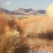
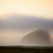
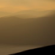
Spanish for ‘Woods of the Apache’, the Bosque del Apache National Wildlife Refuge was established in 1939 to help protect the endangered Sandhill Cranes. Situated on the Rio Grande in south-central New Mexico, 90 miles south of Albuquerque, this tiny high desert wetland serves as a crowded migratory rest stop for thousands of snow geese and 10-15,000 Sandhill Cranes heading down the continent as winter approaches, and again on their return north for breeding season.
Though it’s been eight years since I moved from Maryland’s eastern shore to Santa Fe, I still marvel at the contrast between New Mexico’s high desert wetlands rimmed by 6-7,000’ mountains, to the eastern shore’s low country wetlands surrounded by the Chesapeake Bay. Even more profound, however, is the contrast between the moisture-laden eastern shore light and New Mexico’s high, dry, ever clear atmosphere.
To view more images of Bosque del Apache, see Bosque del Apache II and Bosque del Apache III


2011
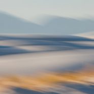
Situated within New Mexico’s south-central Tularosa Basin are 270 square miles of White Sands’ dunes comprising the world’s largest surface deposit of gypsum. Beginning 100 miles south of Albuquerque and continuing 100 miles further south to El Paso, this basin lies within the Rio Grande Rift zone and the Chihuahuan Desert.
Unlike typical quartz sand, gypsum sands’ high rate of surface moisture evaporation reflects rather than absorbs the sun’s rays, making the grains cool to the touch, while taking on the hues of first and last light.
Two hundred and fifty million years ago, enormous upheavals in the Rio Grande Rift formed mountain ranges on both the east and west edges of the Tularosa Basin that uncovered these gypsum deposits, which over time leached into the basin.
In the dunes foreground, sparse golden grasses glow in contrast to the brilliant white dunes which in turn contrast against the formidable mountains both east and west.


2011
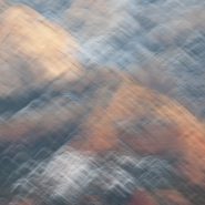
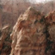
One hundred miles south of the Grand Canyon, Sedona sits in front of the Mogollon rim’s 50 million years of exposed sedimentary layering that evidences the formation of the Colorado Plateau 250 million years ago.
To experience first or last light among its red rocks reveals why Sedona has taken on its own spiritual aura. The red Sandstone and tan mudstone coupled with the immediacy of the formations are breathtaking.


Read More
2011
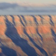
The Edge
The Grand Canyon at first and last light is one of my very favorite places to be with a camera. For the last six years, 5 to 6 times a year for a week or more at a time, I’ve stood at the Canyon’s rim capturing the light playing on and within its voluminous space.
Concentrating on where the canyon walls end and meet what lies beyond 50, even 80 miles to the east and north, I’ve emphasized its vast desert surroundings. At the Grand Canyon, I am able to breathe, focus, and share in its unconditional peace. It is no accident that my images convey the serenity I seek in my life.


2007
Pacific NW Coast III
This is my third series captured during my 2010 roadtrip along the northern California and Oregon coasts. Though rarely blessed with optimal light, I was able to take the time for moments of sun to break through. From the cliffs along the Lost Coast in northern California, to the many rivers flowing into the Pacific, to the wonderfully wide and empty Oregon beaches, to tidal Netarts Bay just north of Cape Lookout contained by a five-mile stretch of beach, the Pacific NW coast is rugged and varied.
The south-flowing Pacific current along the NW coast and the weather, both constantly in motion, offer the perfect foil for overlaying my images with a sense of the passage of time.


2007
Pacific NW coast
In 2010 I made an extensive roadtrip beginning south of the California-Oregon border traveling north along the rugged and beautiful Pacific NW coast to Astoria, overlooking the Columbia River and the Washington border.
Along this coast are intermittent capes protruding into the Pacific that offer expansive cliff views, interspersed with stretches of very wide beaches, sand dunes, and hundreds of haystacks just offshore, plus the many rivers draining the Coastal mountains, this nearly 500 mile stretch of the northwest coast is simply breathtaking. This series plus the next two comprise my October “capture” of this stretch of the Pacific Northwest coast.


2007
Tomales Bay
Tomales Bay, a 15 mile long by mile wide inlet of the Pacific Ocean, separates Point Reyes Peninsula from the Marin County mainland, 30 miles north of San Francisco. The bay forms the eastern boundary of Point Reyes National Seashore and lies along a submerged portion of the San Andreas Fault.
On its northern end, Tomales Bay opens out onto Bodega Bay, which shelters it from the direct current of the Pacific.
Nestled between the Marin hills to the east and the Point Reyes Peninsula’s rolling hills to the west, this tranquil bay offers lovely views of the edges of these two land masses.


Read More
2007
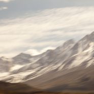
Zabriskie Point lies along the eastern border of California offering sweeping views West across Death Valley’s floor to the Sierra Nevada front-range. The Sierras run 400 miles north-south and 70 miles west-east. Included within this bountiful mountain range is Lake Tahoe, the largest alpine lake in North America, Mount Whitney at 14,505’ the highest point in the contiguous U.S., and Yosemite Valley sculpted by glaciers out of 100 million-year-old granite.
Four million years ago, the Sierra range began to uplift. Subsequent glacial erosion exposed the granite, forming the light-colored mountains we see today. Approaching the Sierra Nevada Range from across Death Valley provides an even more dramatic perspective of the ethereal vertical-rise.


Read More
2007
Marin Headlands
Looking north across the golden gate, the Marin Headlands provide a unique perspective; the contrast of the ocean against the colors and textures on the headland’s face. The headland receives the sunlight directly, and reflectively from the water. The channel provides unobstructed first and last light, while the ever-changing weather plays its part.


2007
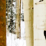
Santa Fe sits on the windward side of the Sangre de Cristo (Blood of Christ) mountain range. This southernmost subrange of the Rocky Mountains extends from Southern Colorado to Glorieta Pass southeast of Santa Fe.
Immediately northeast of Santa Fe, Santa Fe Mountain’s (10,350’) west face is blessed with an enormous aspen stand. Lit by the evening’s last light, they glow atop the mountain for all of Santa Fe to see.
Amongst the Aspens’ beautiful taupe trunks are the occasional aberrant blood-orange boles. Standing out like sentinels, their contrast is truly magical.


1999
Western Space + Time
Having awakened my appetite for large-scale landscape, I explored other western vistas in Wyoming, Utah, California and northern Arizona, in addition to return visits to the high country of Montana. Experimenting with the panoramic format, I found it easier to capture the breadth of the land while more closely matching its flow.
During the creation of this series, I first realized that my obsession with condensing time via motion within a single frame was intimately linked to a lifetime of restlessness.


