2017
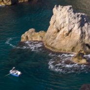
The biggest draw in Southern Croatia is the extraordinary walled city of Dubrovnik, with a remarkable history stretching back well over 1,000 years. Walls up to 80′ high, complete with fortresses and towers, with an ancient footpath along the 2 mile-long wall encircling the stone-built, red-roofed city, offer incredible views of the clearest blue-green waters of the Adriatic. The streets are paved with time-polished pale marble.
The town’s harmony owes much to the 17th century rebuilding program following the Great Earthquake in 1667.


2017
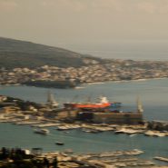
Zagreb is Croatia’s Capital and largest city, with a population of just over 800,000. Split is Croatia’s second largest city, and at 300,000 population the largest city within the Dalmatian region. Situated on the eastern shore of the Adriatic Sea, the city is spread out along a central peninsula.
Home to Diocletian’s Palace, built for the Roman emperor in AD 305, Split was founded as the Greek colony of Aspalathos in the 3rd or 2nd century BC. It became a prominent settlement around 650 AD when it succeeded the ancient capital of the Roman province, Solana.
Split became a Byzantine city, while later gradually drifting into the sphere of the Republic of Venice and the kingdom of Croatia. For much of the High and Middle ages, Split enjoyed autonomy as a free city, caught in the middle of a struggle between Venice and the King of Hungary for control over the Dalmatian cities.
Venice eventually prevailed and during the early modern period Split remained a Venetian city — a heavily fortified outpost surrounded by Ottoman territory. Its hinterland was won from the Ottomans in the Morean War of 1699; in 1797, as Venice fell to Napoleon in the Treaty of Campo Formio, Split went to the Hapsburg Monarchy. In 1805, the Peace of Pressburg added Split to the Napoleonic Kingdom of Italy, becoming part of the Illyrian Provinces in 1809. After being occupied in 1813, it was eventually granted to the Austrian Empire following the Congress of Vienna; the city remained a part of the Austrian Kingdom of Dalmatia until the fall of Austria-Hungary in 1918. Reoccupied by Germany in WWII, Split was part of the puppet State of Croatia. It was liberated again by partisans in 1944 and became part of post-war Socialist Yugoslavia. In 1991, Croatia seceded from Yugoslavia during the Croatian War of Independence.
Centrally situated along the Dalmatian Coast, over the last five years Split has become very much the center of Croatia’s rapidly-growing tourism trade, with its proximity to Italy, miles of Adriatic shore line and countless close and lovely Croatian islands. And its weather is classically Mediterranean!


2003
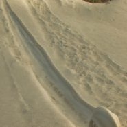
Early one winter morning 15 years ago, driving up Santa Fe Mountain amongst the extensive aspen stands, I rounded a curve to glimpse out of the corner of my eye something I couldn’t believe: slamming on the brakes, I sat looking at a ‟snow spiral” that had formed on a steep slope; after a much closer look, it was obvious to me that it had formed all on it’s own, without any external force other than snow and wind on a steep slope…
Once convinced it had formed naturally, and having never before seen seen anything like it, I spent the next thirty minutes or so capturing it.
Nor have I have seen anything like it since…
Merry Christmas, and Happy New Year!


2018
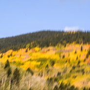
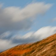
As the temperature drops above 8,000′ elevation in early autumn, the aspen’s leaves commence turning — initially from green to bright yellow, through various hues of gold and lastly to surprising shades of orange — while the tall, slender and graceful trunks subtly shift from white to taupe.
Just north of Santa Fe, along the western edge of the Sangre de Cristo Mountain Range among Santa Fe Mountain’s extensive aspen stands, most of the groves begin their turn dramatically at the same time. Others change at a different pace, depending on their particular exposure to sun and wind.
These out-of-sync aspen turns are invariably more muted, with the leaves’ change often blending closely with their trunks — creating quiet, blended tapestries that are contrasted against nearby evergreens.
Overlaying these quiet forest tapestries with minimal camera strokes enables me to achieve the antidote to my lifetime preoccupation to control time. It’s no accident that my landscapes convey the serenity I have always sought in my own life…


2013
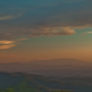
From about 10,000 feet elevation on Santa Fe Mountain — Santa Fe’s ski mountain — where the ski lifts rise to 13,200′ – views toward the South and Southwest offer classic New Mexico mountainous landscape under New Mexico’s equally spectacular, colorful skies.
I moved from the eastern shore of Maryland 15 years ago to place myself at the eastern edge of the amazing landscape throughout America’s west – as have so many artists of all kinds who have moved here over the last 100 years.
Never have I tired of the amazing visual access to nature’s unending western beauty.
I captured this group of pictures one evening while showing the view to out-of-town friends. I spent about an hour capturing some 20 images, from which these five best reflect my 40 year+ compulsion to overlay my images with some sense of the ever-fleeting passage of time.


2012
Fifty miles north of Albuquerque, just north of the junction of U.S. #550 & NM #4, begins the Southern end of the Jemez Mountain Range, which roughly parallels the North-South Sangre de Cristo Mountains 20 miles further east.
Between these mountain ranges lies the Río Grande Rift, into which all surrounding runoff flows, creating the Rio Grande River that originates in the San Juan Mountains in southern Colorado and flows all the way south across the Mexican border.
The small town of San Ysidro is situated at the southern end of the Jemez Mountains, where the Jemez river flows south from the Valles Caldera, joining the Río Grande about half-way to Albuquerque.
San Ysidro is the intersection of four significant geologic features: the Colorado Plateau to the west, the 75 million-year-old Sierra Nacimiento uplift to the north, the Río Grande rift to the east, and the northeast-trending Sierra Jemez lineament, characterized by its young volcanism cutting across all three geologic provinces. The 15 million-year-old Jemez volcanic field is visible to the northeast; the 2 to 3 million-year-old Cabezon Peak is located just to the west. 3.3 million-year-old Mt. Taylor can be seen on the skyline to the west. The surrounding hills are covered with sedimentary red to green siltstones and mudstones, similar to the Painted Desert’s petrified forest Chinle group, deposited on the floodplain of a large west-to-northwest river system some 210 million years ago.
In addition to the red and green stone from the petrified forest, San Ysidro has numerous interesting anticlines and synclines — reflecting the movement of earth structures formed by geological folding.


2014
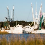
From northern NM high country to South Carolina tidal lowlands amounts to an 8,000’ transformation in elevation.
Water, water and more water, as the tidewater fishing fleet courses amongst the lowlands, always followed by wonderful skimming pelicans…


2015
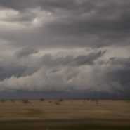
Back home from China in Santa Fe; several weeks later I drove east across the high plains of Oklahoma and the Texas panhandle before heading south to Ft. Worth to see friends. En route, I stopped to have a look at Palo Duro Canyon, situated just south of Amarillo, that claims to be the second largest canyon in the U.S. Typical spring weather — wind and furious thunderstorms across Texas’ high plains — did not disappoint.
Early Spanish Explorers discovered the area and named the canyon “Palo Duro,” Spanish for “hardwood” due to the abundant mesquite and juniper trees. Palo Duro Canyon’s elevation at its rim is 3,500 feet; it is 120 miles long, 20 miles wide, and 800 feet deep, compared to the Grand Canyon — the largest in the U.S. — which is 277 miles long, 18 miles wide, and 6,000 ft deep.
Palo Duro Canyon State Park comprises 30,000 acres at the north end of the canyon. Water erosion from the Red River deepens the canyon as it moves sediment downstream, while wind and water erosion gradually widen the canyon.
Humans have resided in the canyon for approximately 12,000 years. Nomadic tribes hunted mammoth, giant bison, and other large game. Later, Apache Indians lived in the canyon, but were soon replaced by Comanche and Kiowa tribes, who resided in the area until 1874 when Colonel Ranald Mackenzie was sent into the area to transport them to a newly appointed reservation in Oklahoma.
In 1876, Charles Goodnight entered the canyon and opened the JA Ranch, which at its peak, supported more than 100,000 head of cattle.


2014
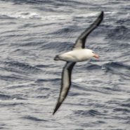
The fossil records of both Albatrosses and Petrels go back nearly 60M years; both are pelagic, since they only return to land to breed. Dominant in the Southern Oceans, albatrosses and giant petrels are convergent, so while not closely related, they have independently evolved similar traits as a result of having to adapt to similar environments.
Albatrosses comprise a group of 22 species of large to very large birds, and are among the largest flying birds. Both albatrosses and petrels are tube-nosed seabirds with strong and sharp-edged bills, with their upper mandible terminating in a large hook. Along each side of their bill are tubes (long nostrils) that enable albatrosses and petrels to measure their exact airspeed during flight – analogous to the pilot tubes in modern aircraft – and thus are highly efficient in the air. With their ability to use dynamic soaring and slope soaring, they are able to cover great distances with minimal exertion.
In addition to wingspans of at least 8-10 feet, albatrosses’ wings are stiff and cambered, with thickened streamlined leading edges. They travel huge distances using two techniques common to any long-winged seabird: dynamic soaring and slope soaring. Dynamic soaring involves repeatedly rising into the wind and descending downwind, thus gaining energy from the vertical wind gradient, with effort only expended in turns at the top and bottom of each loop. This maneuver enables them to cover about 600 miles a day without flapping their wings. Slope soaring uses the rising air on the windward side of large waves. Albatrosses’ very high glide ratios of 22:1 means that they can travel forward a distance 22 times the drop. Further, they are aided in soaring by a shoulder-lock, a sheet of tendon that locks the wing when fully extended, allowing the wing to be outstretched without any muscle expenditure, a morphological adaptation they share with the giant petrels.
All albatrosses are listed to be at some level of endangerment as a result of the serious decline in fish stock, from overfishing, and from being hooked by longline fishing gear. Both feed on squid, fish and krill, by either scavenging, surface seizing, or diving. And their breeding season can take over a year from laying to fledging with a single egg laid in each breeding attempt.
Combining their soaring techniques with their use of predictable weather systems, Albatrosses in the Southern Hemisphere flying north will take a clockwise route, while those flying south will fly counterclockwise. So well adapted to this lifestyle, their heart rates while flying are close to the basal heart rate when resting. Their flying intensity is such that the most energetically demanding aspect of a foraging trip is not the distance covered, but the landings, take-offs and hunting undertaken to find a food source.
Albatrosses live much longer than other birds; they delay breeding far longer and invest more effort into fewer young. Most species survive upwards of 50 years.
Capturing Albatrosses and Petrels in flight by camera, from a moving, bouncing ship in high seas is an exciting and exhausting challenge. With their habit of closely following ships for what might possibly be discharged, plus their natural tendency to glide within the ship’s draft, they definitely try to see just how close they can fly to the ship before having to veer off…


2014
Penguins vs. Skuas
Of the 17 penguin species, Adelies, Chinstraps and Gentoos, averaging 30″ in height (males weigh from 10 to 18 lb., and females slightly less) are the most prominent on the Antarctic peninsula and surrounding islands, where they spend about half their time on land and half in the ocean.
Further south, at the South Pole, where it is much colder, the Emperor Penguin reaches 5′ in height.
Antarctic penguins form breeding colonies ranging from thirty to thousands of pairs, and establish their nesting grounds between June and November. Each of the Antarctic penguins species create their own separate breeding colonies, where each penguin pair construct a nest from stones, grass and moss, in which are laid two white, spherical eggs that are incubated by both male and female for 30 to 40 days. Penguin chicks fledge 2 to 3 months later, but continue to be fed by their parents for 2 to 6 months.
The Gentoo are readily distinguished by their orange-red bill and conspicuous white patches above each eye. They have pale whitish-pink webbed feet and fairly long tails, which is the most prominent tail of all penguins. The gentoo penguin trumpets loudly with its head thrown back.
Antarctic penguins reach sexual maturity at the age of two years, typically return to their previous year’s nest, and are loyal to breeding partners, with many forming long-lasting pair bonds.
Walking with their rather comedic, waddling gate on land, with flippers extended for balance; on downward slopes penguins readily flop over and slide on their bellies. In the water where their streamlined body and flippers provide propulsion up to 20 miles per hour, penguins reach depths of 200 meters in pursuit of their diet of Atlantic krill, squid, and fish.
Breeding on sub-Antarctic islands and the Antarctic peninsula, their non-breeding range is not fully known, but they have been found as far north as New Zealand, Australia and Argentina.
Penguins are the only warm-blooded creature able to tolerate Antarctica winters, which is one of the coldest environments on Earth. A thick layer of fat under their skin, covered by feathers that help to insulate them, provides a waterproof layer for extra protection.
Without any land-based predators, penguins are not afraid or even distressed by humans. Their biggest threat is the Leopard Seal — one of the sourthern-most species of seal and a dominant predator in the Southern Ocean.
Penguins’ single most feared foe, however, is the Skua, a large brownish, highly predatory seabird related to gulls that feed on other birds, penguin eggs and young penguin chicks, making them the penguin’s worst enemy. While skuas nest in southern latitudes, their habitat is open ocean, ranging widely at sea, moving far to the north in both the Atlantic and Pacific, feeding mainly on fish.
Penguins are certainly among the cutest creatures on earth. They are gregarious, living typically in large breeding colonies. Waddling, skimming and honking, and swimming in large groups, and furiously diving for food, their complete lack of concern for humans makes them even more endearing.


Read More
2013
This is my fifth extended visit to Bosque del Apache, one of my favorite locations in New Mexico, 160 miles south of Santa Fe. Created in 1939 to protect the last remaining 17 living sandhill cranes, the Bosque del Apache National Wildlife Refuge’s selective damming of an offshoot of the Rio Grande has developed into nearly 100 sq miles of managed wetlands and adjacent feeding fields, providing a critical stopover for migrating birds including ducks, hundreds of thousands of light geese, and now thousands of sandhill cranes.
In late fall, the bird migrations on their southern trek stop to rest and feed, then return again in early spring as they fly north for mating season. With the first rays of sun, thousands of light geese begin stirring, until their deafening cacophony raises them in waves upon waves, to be followed by hundreds of the much larger and more majestic sandhills in groups of 10 to 20 at a time. Since they only fly to surrounding fields to feed for the day, once the sun begins to set, the light geese and Sandhills rise again and return to the safety of adjoining marshes for the night.
Low-angled winter light on the wetlands, marshes, grain fields and surrounding mountains presents a spectacularly soft tableau.


2012
Two and a half months after my last visit, I’m back in Georgia O’Keefe country. This morning, as it turned out, blessed with moderate cloud cover, I had nearly an hour to capture the soft light playing on Ghost Ranch country’s many layers of siltstone, mudstone and the white to tan sandstone that rivers laid down 200 million years ago when this area was situated only about 10 degrees north of the equator.
To visually emphasize the incredible passage of time that created this dramatic landscape, I chose a soft camera stroke to blend the emulsions in the softened light with the many subtle color layers.
To view more images of Ghost Ranch, see Ghost Ranch I and Ghost Ranch III.


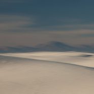
2012
After spending five days over the New Year shooting the Grand Canyon, I photographed my way through the red rocks of Sedona, across the Continental Divide, then dropped down to the Rio Grande, following it south into the Tularosa Basin to shoot at White Sands once again.
Sand dunes are always striking as their organic shapes and patterns constantly change the absorption and reflection of light, but the dunes of White Sands are uniquely special because they reflect the color of the surrounding light more vividly.


2007
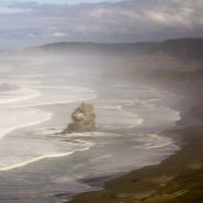
Pacific NW Coast II
Sea stacks — offshore monoliths, also known as haystack rocks — are either the result of portions of headlands splintering off, or from under sea lava flows, or from lava flowing into the sea. Cooling lava became hardened basalt over time; this heavy basalt remained buried under marine sediments for millions of years. As the climate shifted and the sea level receded, the rocks were revealed be either attached to the shoreline or off shore. Their dark shadows cast on the water further accentuate their interesting shapes.
Primarily images of haystacks, I captured this series along the Oregon coast under varied lighting conditions that invariably depended on the degree of cloud cover.


