2012
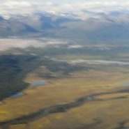
Flying to Anchorage, we rented a car and drove 100 miles north to the old mining town of Talkeetna, where its airfield has become the climber’s gateway to the Alaska Range sixty miles east.
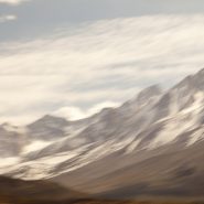
The dominant peak, of course, is Mt. McKinley, also called Denali, the Athabascan name for The High One. At 20,320′, it is the tallest mountain in North America, and since it is situated nearly at sea level, its 18,000′ vertical ascent is the highest of any mountain in the world. Plus, being located at the furthest northern latitude of any major mountain range on Earth, it is also among the coldest and windiest places on Earth!
Flying into the Alaska Range, we landed on the same glacier where two weeks earlier seven Japanese climbers were delivered to begin their ascent. Viewing this mountain from above, it is little wonder, albeit tragic, that only one of the seven survived.
Yet as it was a clear day, our flight to Denali was just spectacular. It is said that only about one third of the people who visit Alaska ever see the top of the Alaska Range. What luck, as we had good weather for three consecutive days.


Read More
2012
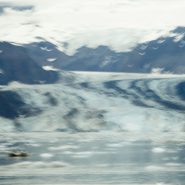
For three days of our Alaskan cruise, we explored from inflatable zodiacs and climbed on numerous glaciers within Glacier Bay — including John Hopkins, Lamplugh, Margerie, and Rendu — seeing many humpback whales, an Orca Whale pod and numerous Sea Otters.
With sunny, clear weather, the glacier blue ice was beautiful. Studying ship-board maps, the up-close and memorable effects of climate change are now indelibly fixed.
Upon exiting Glacier Bay via Lynn Canal, we sailed to our final stop in Juneau, where we disembarked.
A fascinating side note: since my next door neighbor in Santa Fe’s last name is Rendu, I enquired if he had any connection to the Rendu Glacier. Upon researching, he learned that a great, great uncle was a Jesuit Priest who spent a number of years in Alaska, and it was he who Rendu Glacier was named after.


2013
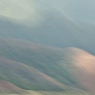
The interior of Hawaii’s “Garden Isle”, cries out to be captured with panoramic composition. As the flowing lava built up and solidified over several million years, it formed subtle exaggerated layers, which turn increasingly abstract as the colors meld with the sky.
Oh, to have one’s own helicopter, or better yet, imagine what could be captured with a camera attached to one of the new quadcopter drones!


2012
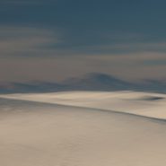
After spending five days over the New Year shooting the Grand Canyon, I photographed my way through the red rocks of Sedona, across the Continental Divide, then dropped down to the Rio Grande, following it south into the Tularosa Basin to shoot at White Sands once again.
Sand dunes are always striking as their organic shapes and patterns constantly change the absorption and reflection of light, but the dunes of White Sands are uniquely special because they reflect the color of the surrounding light more vividly.


2007
Zabriskie Point lies along the eastern border of California offering sweeping views West across Death Valley’s floor to the Sierra Nevada front-range. The Sierras run 400 miles north-south and 70 miles west-east. Included within this bountiful mountain range is Lake Tahoe, the largest alpine lake in North America, Mount Whitney at 14,505’ the highest point in the contiguous U.S., and Yosemite Valley sculpted by glaciers out of 100 million-year-old granite.
Four million years ago, the Sierra range began to uplift. Subsequent glacial erosion exposed the granite, forming the light-colored mountains we see today. Approaching the Sierra Nevada Range from across Death Valley provides an even more dramatic perspective of the ethereal vertical-rise.


Read More