2013
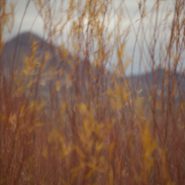
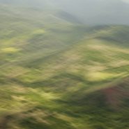
This is my fifth extended visit to Bosque del Apache, one of my favorite locations in New Mexico, 160 miles south of Santa Fe. Created in 1939 to protect the last remaining 17 living sandhill cranes, the Bosque del Apache National Wildlife Refuge’s selective damming of an offshoot of the Rio Grande has developed into nearly 100 sq miles of managed wetlands and adjacent feeding fields, providing a critical stopover for migrating birds including ducks, hundreds of thousands of light geese, and now thousands of sandhill cranes.
In late fall, the bird migrations on their southern trek stop to rest and feed, then return again in early spring as they fly north for mating season. With the first rays of sun, thousands of light geese begin stirring, until their deafening cacophony raises them in waves upon waves, to be followed by hundreds of the much larger and more majestic sandhills in groups of 10 to 20 at a time. Since they only fly to surrounding fields to feed for the day, once the sun begins to set, the light geese and Sandhills rise again and return to the safety of adjoining marshes for the night.
Low-angled winter light on the wetlands, marshes, grain fields and surrounding mountains presents a spectacularly soft tableau.


2013
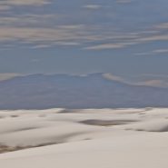
At 4,000′ elevation, the 275 square mile White Sands’ dune field comprises the world’s largest surface deposit of gypsum. Located 250 miles south of Albuquerque, and just north of the White Sands Missle Test Center, White Sands National Monument is situated in New Mexico’s Tularosa Basin between two 8-9,000′ North-South mountain ranges — the San Andreas Mountains to the west, and the Sacramento Mountains to the east.
The white gypsum sand is unlike typical desert sands made of quartz, or sand found on most beaches. Because the white gypsum reflects the sun’s rays resulting in a high rate of evaporation of surface moisture, the white gypsum sand is cool to the touch.
Because of southern New Mexico’s exceptionally clear weather, Germany trains their fighter pilots from an airbase 20 miles SE of White Sands; often they leave contrails that contrast dramatically against New Mexico’s blue, blue skies.


2013
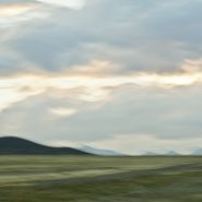
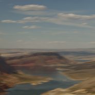
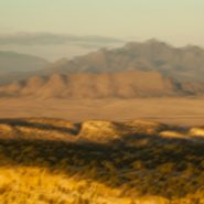
San Luis Valley — 8,000 sq. miles, averaging 7,600′ elevation — is the largest high desert valley in North America. Situated in south central Colorado, with a small portion extending south into central New Mexico, this gradually-sloping, 122 mile long north-to-south flat basin, 74 miles wide, separates Colorado’s two largest mountain ranges – the San Juans to the west, and the Sangre de Cristos to the east.
As part of the Rio Grande Rift, San Luis Valley extends east from the Continental Divide. The Rio Grande River rises out of the eastern San Juan Mountains and flows south into New Mexico; Colorado rivers west of the Continental Divide are drained by the Colorado River. Receiving little precipitation, the San Luis Valley is comprised of desert lands; with no clear southern boundary, it is generally considered to include the San Luis Hills of southern Colorado and the Taos Plateau of northern New Mexico.
Along the eastern edge of San Luis Valley are two significant features:
Blanca Peak, at 14,351′, is the fourth highest mountain in Colorado, and the highest peak in the Sangre de Cristo Mountains. Situated at the southern end of the more extensive Sangre de Cristo Range, it is the highest peak in both ranges, and is located 20 miles east-northeast of the town of Alamosa. Blanca Peak is also the highest point of the entire drainage basin of the Rio Grande, and is higher than any point in the U.S. east of its longitude.
Fifteen miles northwest of Blanca Peak, the Great Sand Dunes National Park and Preserve is situated in the lee of the Sangre de Cristos. These sand dunes, reaching as high as 750′, are the highest in North America.


2013
At 12,095′ elevation, this narrow strip of the Continental Divide is the high and extensive Sawatch Range of the Rocky Mountains of central Colorado. Situated midway between Aspen and Twin Lakes, it includes eight of the twenty highest Rocky Mountain peaks. Independence Pass is the highest paved crossing of the Continental Divide in the US.
Overlooking the alpine tundra environment above the treeline, Independence Pass offers incredible views east of Mt. Elbert, Colorado’s highest peak, and the second highest mountain in the contiguous United States.


2013
The Green River is both the inflow and outflow of Flaming Gorge Reservoir, whose elevation when full is 6,040′. Created in 1964 by the completion of the Flaming Gorge Dam, the reservoir is mostly situated in Wyoming, as its northern tip is only 14 miles southwest of Rock Springs, WY. Just its southern end dips into northeastern Utah.
Rising out of western Wyoming’s Wind River Mountains, the Green River is the principal tributary of the Colorado River. During John Wesley Powell’s 1869 expedition down the Green River, he named the Flaming Gorge for its spectacular red sandstone cliffs surrounding this part of the river. The Green River continues south through Utah, before it merges with the Colorado River 40 miles into western Colorado.


Read More
2013
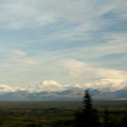
Another Rocky Mountain range in Western Wyoming, The Winds run generally NW-SE for about 100 miles, and include more than 40 peaks in excess of 13,000′. Gannett Peak, at 13,809′ is the highest mountain in Wyoming, though only 33′ higher than the 13,776′ Grand Teton. Except for Grand Teton, the next 19 highest peaks in Wyoming, are in The Winds. Two National Forests and three wilderness areas encompass most of the Wind River Range, as the Continental Divide follows its crest.
Shoshone National Forest on its east side, and Bridger-Teton National Forest to the west, and the entire Wind River range, are all part of the Greater Yellowstone Ecosystem. Portions of the range are also within the Wind River Indian Reservation.
Indigenous peoples of the Great Basin, such as the Shoshones and Absarokas (Crow) Native Americans lived in the range beginning 7,000 and 9,000 years ago.


2013
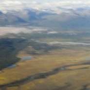
The Snake River’s headwaters are formed at the consolidation of three tiny streams, at an elevation of nearly 9,000′, on the southwest flank of Two Oceans Plateau situated in western Wyoming’s portion of Yellowstone National Park.
Flowing south through Jackson Lake, the ninth longest river in the US continues on south through Jackson Hole valley between the Tetons and Wind River Range, before making a large western sweep through southern Idaho’s Snake River Canyon, and then northwest through Oregon and Washington, where it becomes the Columbia River’s largest tributary, as well as the largest North American river to empty into the Pacific Ocean.
Looking east from the Tetons – the Snake continues its 1,078 mile journey to the Pacific — between the Tetons and The Wind River Range — as it flows south through Jackson Hole.


2013
Originally referred to as the East Fork of the Yellowstone River, the 40 mile long Lamar River rises out of the Absaroka Range along the eastern border of Yellowstone National Park, and meanders northwest and then west to where it flows into the Yellowstone River south of the Montana Border. The wide, expansive Lamar Valley is home to bison, elk, coyote, grizzly and wolf.
In 1995, wolves were re-introduced in the northeast corner of Yellowstone Park along the Lamar River at Soda Butte, Crystal Creek and Rose Creek.


2013
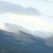
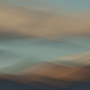
The 9th of ten successive explorations of the Santa Fe Baldy portion of the Sangre de Cristo range, immediately north of Santa Fe.
Winter’s earlier, crisper light emphasizes Santa Fe Baldy’s west face, especially when framed with low hanging clouds.


2013
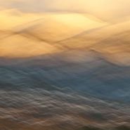
As winter sets in I continue my visual explorations of the Sangre de Cristo mountain ridge surrounding New Mexico’s 4th highest peak, Santa Fe Baldy.
Blending the snow-covered mountains’ more subtle palette allows for a very different interpretation…


2013
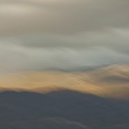
Continuing my visual explorations just north of Santa Fe, as the weather turns, the contrast of light, clouds and first snow intensifies against the 12,000′ Sangre de Cristo mountain ridge that surrounds New Mexico’s 4th highest peak, Santa Fe Baldy.
In turn, this further reduction of my blended elements to three emphasizes how I see and interpret this landscape.


2013
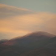
This is the fifth of ten successive explorations of light’s effect on the Santa Fe Baldy portion of the Sangre de Cristo mountain range, just north of Santa Fe. At 12,632′ elevation, Santa Fe Baldy is especially susceptible to ‛nearly last light,’ particularly when nearby clouds take on hues that compliment the mountain peak.


2013
Returning once again to the Bosque del Apache in cold January, I wait for first light as it gradually warms the soft wetlands and rouses thousands of migrating fowl. Tens of thousands of snow geese and thousands of Sandhill Cranes raise an amazing raucous as they begin lifting off the water to spread out amongst the adjoining fields of grain. Though the snow geese are quicker to gain flight, the Sandhills with their six-foot wing spans are truly majestic as they slowly rise in powerful flight.
Bosque del Apache National Wildlife Refuge was established in 1939 to protect the last remaining 17 living Sandhill Cranes. By creating a wetlands area off a turn of the Rio Grande seventy-five years ago, Bosque del Apache has served as the major high desert refuge for the Sandhills, various strains of geese, and countless ducks migrating south in fall and returning in early spring.
Against the Chupadera Mountains to the west, the contrast of the wetlands’ water and foliage illuminated by early light makes for a photographer’s dream.


2012
Just south of Santa Fe at the southern terminus of the Rocky Mountains, the Galisteo Basin begins a 2,500′ elevation descent south over 40 miles to the Sandias adjacent to Albuquerque; And to the west it stretches beyond the Rio Grande Rift to the southern end of the foothills of the Jemez Mountains.
Surrounded by these three mountain ranges, the Galisteo Basin’s classic northern New Mexico high desert landscape offers dramatic views in all directions. Having introduced three Galisteo Basin image series captured in 2011, this posting comprises a series of the Galisteo Basin captured from a morning helicopter flight in 2012.
To view more images of the Galisteo Basin, see Galisteo Basin I, Galisteo Basin II and Galisteo Basin III.


2012
Now that we had flown over the Peter’s Hills to the beginning of Denali’s vertical ascent, in and around this incredibly steep range, landed on and taken off from a glacier, circled the northern side of Denali, and returned the 60 miles back to Talkeetna, the challenge was to capture the entire Denali Mountain from afar. And luck was with us, as it was clear as a bell!
The Alaska Range is the highest in the world outside of Asia and the Andes. It forms a generally east-west arc with its northernmost portion in the center. Acting as a high barrier to the flow of moist air from the Gulf of Alaska northwards, The Alaska Range has some of the harshest weather in the world.


2012
Flying to Anchorage, we rented a car and drove 100 miles north to the old mining town of Talkeetna, where its airfield has become the climber’s gateway to the Alaska Range sixty miles east.
The dominant peak, of course, is Mt. McKinley, also called Denali, the Athabascan name for The High One. At 20,320′, it is the tallest mountain in North America, and since it is situated nearly at sea level, its 18,000′ vertical ascent is the highest of any mountain in the world. Plus, being located at the furthest northern latitude of any major mountain range on Earth, it is also among the coldest and windiest places on Earth!
Flying into the Alaska Range, we landed on the same glacier where two weeks earlier seven Japanese climbers were delivered to begin their ascent. Viewing this mountain from above, it is little wonder, albeit tragic, that only one of the seven survived.
Yet as it was a clear day, our flight to Denali was just spectacular. It is said that only about one third of the people who visit Alaska ever see the top of the Alaska Range. What luck, as we had good weather for three consecutive days.


Read More
2013
Stretching across Kauai’s northern end, the Na Pali coast’s steep, dramatic terrain is rimmed with narrow beaches and booming surf. It’s vivid colors range from the lush tropical greens to the island’s red, oxidized basaltic foundation and a myriad of colors in between. The crystal clear sunlight intermittently filtered by the voluminous clouds adds a vast and brilliant pacific blue border for this magnificent coast.
I have yet to have a bad day – light wise or cloud-wise – on Kauai! Having lived for the last ten years in the southwest’s high desert country, it was truly a luxury…


2011
Early winter light warms the soft wetlands screened against the hard Chupadera Mountains as the rising sun awakens thousands of migrating fowl. The Snow Geese’s cacophony builds and 10,000 Sandhill Cranes begin lifting off in twos and threes with their six-foot wing spans slowly, powerfully, pumping them upward.
President Clinton used to say: “It’s the economy, stupid.” With landscape, it’s the light! Never is that more pronounced than in early winter at Bosque del Apache National Wildlife Refuge with the Sandhills flying.
To view more images of Bosque del Apache, see Bosque del Apache and Bosque del Apache II


2012
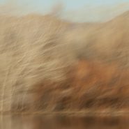
Two and a half months after my last visit, I’m back in Georgia O’Keefe country. This morning, as it turned out, blessed with moderate cloud cover, I had nearly an hour to capture the soft light playing on Ghost Ranch country’s many layers of siltstone, mudstone and the white to tan sandstone that rivers laid down 200 million years ago when this area was situated only about 10 degrees north of the equator.
To visually emphasize the incredible passage of time that created this dramatic landscape, I chose a soft camera stroke to blend the emulsions in the softened light with the many subtle color layers.
To view more images of Ghost Ranch, see Ghost Ranch I and Ghost Ranch III.


2012
The Bosque’s most celebrated season begins with the arrival of the Sandhill Cranes in mid-November and lasts until January-February when they head north to breed. Honking and calling 10-15,000 strong, the Sandhills congregate in groups among thousands of Snow Geese creating a spectacular migratory stop in the desert sands.
Sandhills appear gangly standing in the water on their long skinny legs. Yet as one of North America’s larger water fowl with wingspans reaching six feet, they are definitely the stars of the Bosque show.
To view more images of Bosque del Apache, see Bosque del Apache I and Bosque del Apache III


