2013
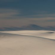
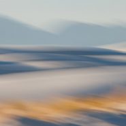
Situated in New Mexico’s Tularosa Basin, between two 8-9,000′ mountain ranges — the San Andres Mountains to the west and Sacramento Mountains to the east —White Sands, unlike most desert sands made of quartz, is composed of gypsum and calcium sulfate. Unlike sand found on most beaches, white sand is cool to the touch, due to the high rate of evaporation of surface moisture and the fact that the sand reflects rather than absorbs the sun’s rays. At an average 4,000′ elevation, the estimated 275 square miles of White Sands’ dune fields is known as the world’s largest surface deposit of gypsum.
Equally fascinating is how low-angled winter light casts diverse color onto the bright white gypsum sand. Shadowed low and flat light casts blue when shooting west toward last light, while early light casts an orange glow on the gypsum sand.
This is my third visit to White Sands. Each time I see it differently, and each time I come away with images that greatly excite me. A little over a year ago I hung a show at Las Cruces Museum, eleven images from my three visits including three from this series.


2012
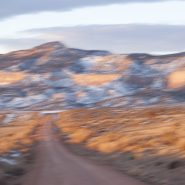
Just south of Santa Fe at the southern terminus of the Rocky Mountains, the Galisteo Basin begins a 2,500′ elevation descent south over 40 miles to the Sandias adjacent to Albuquerque; And to the west it stretches beyond the Rio Grande Rift to the southern end of the foothills of the Jemez Mountains.
Surrounded by these three mountain ranges, the Galisteo Basin’s classic northern New Mexico high desert landscape offers dramatic views in all directions. Having introduced three Galisteo Basin image series captured in 2011, this posting comprises a series of the Galisteo Basin captured from a morning helicopter flight in 2012.
To view more images of the Galisteo Basin, see Galisteo Basin I, Galisteo Basin II and Galisteo Basin III.


2012
The Sangre de Cristo (Blood of Christ) Mountain range is the southernmost subrange of the Rockies; they begin in Southern Colorado and extend south to just below Santa Fe. At the north end of town, on the Sangre’s western slope is Santa Fe Mountain, whose west face is covered with very large Aspen stands.
Native to cold regions with cool summers at altitudes above 5,000 feet, aspens are medium-sized deciduous trees reaching as high as 100′. They generally grow in large colonies derived from a single seedling and spread by means of root suckers whose new stems may appear more than 100 feet from the parent tree. While each individual tree can live for 40 to 150 years, they send up new trunks as the older trunks die off above ground, so their root systems are long-lived, in some cases for thousands of years, which is why aspen stands are considered to be ancient woodlands.
Come the end of September through mid-October, the west face of Santa Fe Mountain lights up as the Aspen leaves turn their beautiful, riotous, yellow. Illuminated by the lower angle of fall sunsets, the light is just magical.


Read More
2012
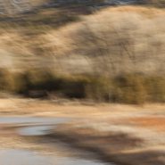
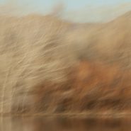
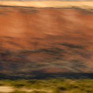
Warm early March light on this lovely array of high desert colors, just north of Abiquiu Lake, leading west from Ghost Ranch along the dirt road to the Monastery of Christ in the Desert…
‘Georgia O’Keefe country’ is an hour north of Santa Fe, and lies within the broad shallow Chama Basin along the eastern margin of the Colorado Plateau as it transitions toward the Rio Grande Rift further east. Because the Colorado Plateau has been a relatively stable block in the Earth’s crust for at least 600 million years, the rocks around Ghost Ranch are generally flat-lying and less deformed by broad-scale folding.
The oldest exposed rocks in the ghost ranch area belong to a thick layer of brick-red to red siltstone and mudstone, and mudstone and white to tan sandstone. Deposited more than 200+ million years ago when the Ghost Ranch area was located just 10 degrees north of the equator these varicolored cliffs provide its signature palette, when raised by low-angled light.
Blended with motion, it is my intent that this palette suggest its millions of years’ passage of time.
To view more images of Ghost Ranch, see Ghost Ranch and Ghost Ranch II.


2013
Zocalo is a residential community designed in the form of clustered “casitas” at the northern edge of Santa Fe by world-renowned Mexican architect Ricardo Legorreta. Spanish for “town square”, Zocalo sits in the lee of the Sangre de Cristo Mountains and reflects so beautifully Legorreta’s signature use of brilliant reds and yellows in dramatic contrast to the snow-capped mountains above. The high desert setting sun even further accentuates Legorreta’s warm ‘Mexican colors’.


2011
Early winter light warms the soft wetlands screened against the hard Chupadera Mountains as the rising sun awakens thousands of migrating fowl. The Snow Geese’s cacophony builds and 10,000 Sandhill Cranes begin lifting off in twos and threes with their six-foot wing spans slowly, powerfully, pumping them upward.
President Clinton used to say: “It’s the economy, stupid.” With landscape, it’s the light! Never is that more pronounced than in early winter at Bosque del Apache National Wildlife Refuge with the Sandhills flying.
To view more images of Bosque del Apache, see Bosque del Apache and Bosque del Apache II


2012
Two and a half months after my last visit, I’m back in Georgia O’Keefe country. This morning, as it turned out, blessed with moderate cloud cover, I had nearly an hour to capture the soft light playing on Ghost Ranch country’s many layers of siltstone, mudstone and the white to tan sandstone that rivers laid down 200 million years ago when this area was situated only about 10 degrees north of the equator.
To visually emphasize the incredible passage of time that created this dramatic landscape, I chose a soft camera stroke to blend the emulsions in the softened light with the many subtle color layers.
To view more images of Ghost Ranch, see Ghost Ranch I and Ghost Ranch III.


2012
The Bosque’s most celebrated season begins with the arrival of the Sandhill Cranes in mid-November and lasts until January-February when they head north to breed. Honking and calling 10-15,000 strong, the Sandhills congregate in groups among thousands of Snow Geese creating a spectacular migratory stop in the desert sands.
Sandhills appear gangly standing in the water on their long skinny legs. Yet as one of North America’s larger water fowl with wingspans reaching six feet, they are definitely the stars of the Bosque show.
To view more images of Bosque del Apache, see Bosque del Apache I and Bosque del Apache III


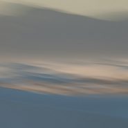
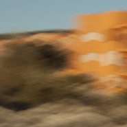
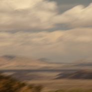
2012
After spending five days over the New Year shooting the Grand Canyon, I photographed my way through the red rocks of Sedona, across the Continental Divide, then dropped down to the Rio Grande, following it south into the Tularosa Basin to shoot at White Sands once again.
Sand dunes are always striking as their organic shapes and patterns constantly change the absorption and reflection of light, but the dunes of White Sands are uniquely special because they reflect the color of the surrounding light more vividly.


Looking at a book on Alaskan Totem Poles a few years ago got me thinking that totems were panoramics turned on their end. (more…)
Read More
I must confess that my bird images started out, and continue even now, mostly to be a by-product of my landscape photography, which invariably involves a lot of waiting for the light. And waiting is not one of my strong suits. (more…)
Read More
At last, four years ago, I transferred completely over to Digital Capture. For 6 years prior to that I lived in both camps. (more…)
Read More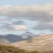
2011
The Truchas Peaks are 25 miles northeast of Santa Fe in the Sangre de Cristo Mountains. Spanish for “trout”, it is north-south trending with four identifiable summits including South Truchas Peak, 13,102’, the second highest independent peak in New Mexico and North Truchas Peak, 13,024’.
The birth of the Sangre de Cristos Mountains, the southernmost subrange of the Rockies, began 80 million years ago when the Farallon Plate slid under the North American Plate at such a shallow subduction, it created a broad belt of mountains running down North America. The low angle moved the focus of crustal melting and mountain building much farther inland than the normal 2-300 miles. Over the past 60 million years, erosion stripped away the high rocks, revealing the ancestral rocks beneath, which have since been eroded by water and glaciers to sculpt the Rockies into dramatic peaks and valleys.
I was fortunate to capture Truchas Peaks in late light, immediately following the first snow.


Read More
2011
“It is not a country of light on things. It is a country of things in light.”
—Georgia O’Keefe
An hour north of Santa Fe, begins a landscape of vast vistas, flat-topped mesas, and tall cliffs with winding rivers bordered by huge old cottonwood trees. Ghost Ranch lies in the broad shallow Chama Basin along the eastern margin of the Colorado Plateau as it transitions toward the Rio Grande Rift further east. Occupying parts of New Mexico, Arizona, Utah and Colorado, the Colorado Plateau has been a relatively stable block in the Earth’s crust for at least 600 million years; consequently the rocks around Ghost Ranch are generally flat-lying and less mildly deformed by broad-scale folding.
The oldest rocks exposed in the Ghost Ranch area belong to a thick package of brick-red to red siltstone and mudstone and white to tan sandstone, deposited by rivers more than 200 million years ago when the Ghost Ranch area was located about 10 degrees north of the equator.
In 1929, painter Georgia O’Keefe first began working part of the year in northern New Mexico, which she made her permanent home in 1949. Between 1929 and 1949, she spent part of nearly every year working in New Mexico. Then in 1934 she first visited Ghost Ranch, north of Abiquiu and decided immediately to live there.
Ghost Ranch’s varicolored cliffs inspired some of her most famous landscapes. “The cliffs over there are almost painted for you – you think – until you try to paint them.” O’Keefe wrote in 1977. “Such a beautiful, untouched, lonely feeling place, such a fine part of what I call the ‘Faraway’. It is a place I have painted before…even now I must do it again.” So how can I resist painting this same landscape with my camera, using the foil of time to render my own interpretation?
To view more images of Ghost Ranch, see Ghost Ranch II and Ghost Ranch III.


Read More
2011
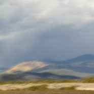
Concentrating once again on the Galisteo Basin, situated between Santa Fe and Albuquerque, I captured the mountain ranges in its south and west quadrants, plus to the north the very southern end of the last of the Sangre de Cristo foothills – such beautiful high desert light emphasizing their relative elevations.
To view more images of Galisteo Basin, see Galisteo Basin I and Galisteo Basin II


2011
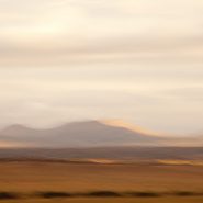
So taken by this basin’s spectacular views at Santa Fe’s southern doorstep, I find myself returning again and again.
An upwelling of the Earth’s mantle thirty million years ago caused a pair of parallel fault zones, 40 miles apart, to cut north-south through New Mexico from the San Juan Mountains in south central Colorado to the southwestern tip of Texas; 8-10 million years later, this slice of the Earth’s crust sank as much as 5 miles, creating the Rio Grande Rift, which in turn extended a network of fault patterns that pulled apart the Earth’s crust to the breaking point. From the Rio Grande Rift west to the Sierras, these faults were the genesis of the southwest’s predominate Basin & Range topography: fallen crustal blocks created basins; uplifted blocks became mountain ranges.
Low-angled high-desert light with some cloud cover makes it possible to emphasize the differing characters of these surrounding mountains
To view more images of Galisteo Basin, see Galisteo Basin I and Galisteo Basin III


2011
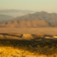
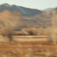
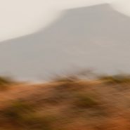
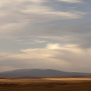
The Galisteo Basin is classic northern New Mexico high desert landscape. Surrounded by very visible mountain ranges this basin is situated on the east side of the Rio Grande between Santa Fe and Albuquerque. Tilted, and interspersed with wide-open plateaus, the basin offers dramatic views in all directions.
This particular series is the result of one afternoon’s roadtrip south from Galisteo to Stanley, along the east side of the Ortiz, Captain Davis and Lone Mountains, and further south, east of the Sandia Mountains.
Like so much of the American west, what is visible today was formed over the last 30 million years, amounting to less than 1% of the Earth’s 4.6 billion year age
To view more images of Galisteo Basin, see Galisteo Basin II and Galisteo Basin III


2011
Situated within New Mexico’s south-central Tularosa Basin are 270 square miles of White Sands’ dunes comprising the world’s largest surface deposit of gypsum. Beginning 100 miles south of Albuquerque and continuing 100 miles further south to El Paso, this basin lies within the Rio Grande Rift zone and the Chihuahuan Desert.
Unlike typical quartz sand, gypsum sands’ high rate of surface moisture evaporation reflects rather than absorbs the sun’s rays, making the grains cool to the touch, while taking on the hues of first and last light.
Two hundred and fifty million years ago, enormous upheavals in the Rio Grande Rift formed mountain ranges on both the east and west edges of the Tularosa Basin that uncovered these gypsum deposits, which over time leached into the basin.
In the dunes foreground, sparse golden grasses glow in contrast to the brilliant white dunes which in turn contrast against the formidable mountains both east and west.


2007
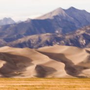
As the sun drops behind the San Juan Mountains, 75 miles across the San Luis Valley, the last direct light on North America‘s tallest and highest dunes causes the volcanic sand to glow.
This Colorado dune field evolved out of the last major volcanic activity in the San Juan Mountains, 30 million years ago. The Rio Grande carried volcanic ash eastward, while prevailing southwesterly winds plus the snowmelt from the Sangre de Cristo Mountains have maintained its unique balance.
My own visual interpretation of the events that have created this particular evolution in the passage of time is not unlike The Jicarilla Apaches’ “it goes up and down” and the Utes’ “the land that moves back and forth.”


2007
Driving West to the Grand Canyon from Santa Fe, five miles east of the Continental Divide, at 7,200’ elevation, the sun’s low angle dramatically rakes the south face of the Colorado Plateau’s sandstone cliffs.


